IMAGES TAKEN NEAR TO
Llanbrook, Clunton, CRAVEN ARMS, SY7 0QG
Introduction
This page details the photographs taken nearby to SY7 0QG by members of the Geograph project.
The Geograph project started in 2005 with the aim of publishing, organising and preserving representative images for every square kilometre of Great Britain, Ireland and the Isle of Man.

There are currently over 7.5m images from over14,400 individuals and you can help contribute to the project by visiting https://www.geograph.org.uk
Image Map
Images are licensed for reuse under creativecommons.org/licenses/by-sa/2.0
Notes
- Clicking on the map will re-center to the selected point.
- The higher the marker number, the further away the image location is from the centre of the postcode.
Image Listing (3 Images Found)
Images are licensed for reuse under creativecommons.org/licenses/by-sa/2.0
Image
Details
Distance
1
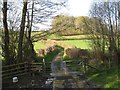
Ford and lane
A ford and footbridge over the un-named stream on the lane to Llanhowell.
Image: © Jonathan Wilkins
Taken: 15 Apr 2017
0.08 miles
2
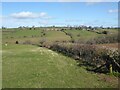
Farmland above Llanbrook
Farmland above Llanbrook to the west of Hopton Castle.
Image: © Philip Halling
Taken: 14 Mar 2022
0.22 miles
3
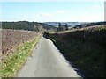
Road to Hopton Castle
Titterstone Clee Hill is visible from here though not in this picture.
Image: © Philip Halling
Taken: 14 Mar 2022
0.23 miles