IMAGES TAKEN NEAR TO
Broome Road, CRAVEN ARMS, SY7 0PW
Introduction
This page details the photographs taken nearby to Broome Road, SY7 0PW by members of the Geograph project.
The Geograph project started in 2005 with the aim of publishing, organising and preserving representative images for every square kilometre of Great Britain, Ireland and the Isle of Man.

There are currently over 7.5m images from over14,400 individuals and you can help contribute to the project by visiting https://www.geograph.org.uk
Image Map
Images are licensed for reuse under creativecommons.org/licenses/by-sa/2.0
Notes
- Clicking on the map will re-center to the selected point.
- The higher the marker number, the further away the image location is from the centre of the postcode.
Image Listing (27 Images Found)
Images are licensed for reuse under creativecommons.org/licenses/by-sa/2.0
Image
Details
Distance
3
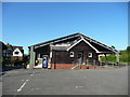
Clungunford Village Hall
The new incorporates the old here.
Image: © Jeremy Bolwell
Taken: 7 Sep 2012
0.11 miles
4
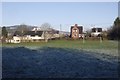
Football pitch, Clungunford
Playing fields in the middle of the village.
Image: © Richard Webb
Taken: 28 Dec 2017
0.11 miles
5
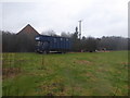
Old horse transporter in the paddock
A slightly grand description for an old disused lorry that has seen better days.
Image: © Jeremy Bolwell
Taken: 12 Feb 2017
0.12 miles
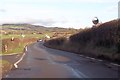
7
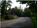
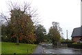
The B4367 at Clungunford
Around the corner and left towards Craven Arms
Image: © Eirian Evans
Taken: 30 Apr 2011
0.13 miles
9
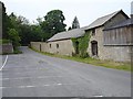
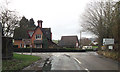
Stone barn, Clungunford
On Chapel Road, the car park serves the sports club and the village hall.
Image: © Penny Mayes
Taken: 8 Jun 2007
0.14 miles