IMAGES TAKEN NEAR TO
Rowton, Aston-on-Clun, CRAVEN ARMS, SY7 0NZ
Introduction
This page details the photographs taken nearby to SY7 0NZ by members of the Geograph project.
The Geograph project started in 2005 with the aim of publishing, organising and preserving representative images for every square kilometre of Great Britain, Ireland and the Isle of Man.

There are currently over 7.5m images from over14,400 individuals and you can help contribute to the project by visiting https://www.geograph.org.uk
Image Map
Images are licensed for reuse under creativecommons.org/licenses/by-sa/2.0
Notes
- Clicking on the map will re-center to the selected point.
- The higher the marker number, the further away the image location is from the centre of the postcode.
Image Listing (17 Images Found)
Images are licensed for reuse under creativecommons.org/licenses/by-sa/2.0
Image
Details
Distance
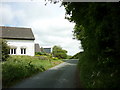
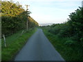
3
Country lane in Shropshire
The building ahead belongs to Viewedge Farm. Both the building and the gate entrance on the right are new.
Image: © Jeff Buck
Taken: 18 Sep 2009
0.06 miles
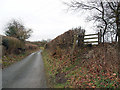
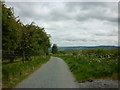
5
Lane below View Edge
The lane is cooling as the sun sinks westwards.
Image: © Jeremy Bolwell
Taken: 6 Sep 2012
0.09 miles
8
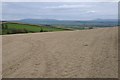
The Clee Hills
The Clee Hills, Brown Clee and Titterstone Hill viewed from View Edge or Weo Edge.
Image: © Philip Halling
Taken: 23 Apr 2018
0.11 miles
9
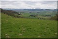
View west from View Edge
View westwards across Shropshire towards Wales from View Edge.
Image: © Philip Halling
Taken: 23 Apr 2018
0.12 miles