IMAGES TAKEN NEAR TO
Bedstone, BUCKNELL, SY7 0BL
Introduction
This page details the photographs taken nearby to SY7 0BL by members of the Geograph project.
The Geograph project started in 2005 with the aim of publishing, organising and preserving representative images for every square kilometre of Great Britain, Ireland and the Isle of Man.

There are currently over 7.5m images from over14,400 individuals and you can help contribute to the project by visiting https://www.geograph.org.uk
Image Map
Images are licensed for reuse under creativecommons.org/licenses/by-sa/2.0
Notes
- Clicking on the map will re-center to the selected point.
- The higher the marker number, the further away the image location is from the centre of the postcode.
Image Listing (6 Images Found)
Images are licensed for reuse under creativecommons.org/licenses/by-sa/2.0
Image
Details
Distance
3
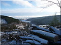
Snowy Darky Dale
Lovely snowscene above Darky Dale.
Image: © Jeremy Bolwell
Taken: 21 Dec 2009
0.13 miles
5
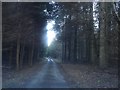
Darky Dale Lane - 1
View eastwards from the end of the lane. Appropriate name as it carves through mature conifers with light at a premium.
Image: © Trevor Rickard
Taken: 9 Jan 2008
0.23 miles
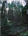
6
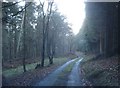
Darky Dale Lane - 2
Tracking south-east through the forest on Bedstone Hill.
Image: © Trevor Rickard
Taken: 9 Jan 2008
0.24 miles