IMAGES TAKEN NEAR TO
BUCKNELL, SY7 0AB
Introduction
This page details the photographs taken nearby to SY7 0AB by members of the Geograph project.
The Geograph project started in 2005 with the aim of publishing, organising and preserving representative images for every square kilometre of Great Britain, Ireland and the Isle of Man.

There are currently over 7.5m images from over14,400 individuals and you can help contribute to the project by visiting https://www.geograph.org.uk
Image Map
Images are licensed for reuse under creativecommons.org/licenses/by-sa/2.0
Notes
- Clicking on the map will re-center to the selected point.
- The higher the marker number, the further away the image location is from the centre of the postcode.
Image Listing (192 Images Found)
Images are licensed for reuse under creativecommons.org/licenses/by-sa/2.0
Image
Details
Distance
1
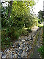
Dried up River Redlake at Bucknell
No water flowing through Bucknell here, although there was some in the river just a few hundred yards up the valley.
Image: © Andrew Shannon
Taken: 21 Sep 2021
0.01 miles
2
![Bucknell buildings [6]](https://s1.geograph.org.uk/geophotos/06/92/39/6923917_40b5ee87_120x120.jpg)
Bucknell buildings [6]
Alongside The Causeway is this barn, built in the mid 17th century with later alterations. Set on a rubble stone plinth, timber framed and clad in corrugated iron and weatherboard under a corrugated iron roof. Listed, grade II, with details at: https://historicengland.org.uk/listing/the-list/list-entry/1054987
Bucknell is a village in south Shropshire, on the River Redlake, some 6 miles east of Knighton and very near the boundaries with Wales and Herefordshire. The village has been occupied since Saxon times and there are the remains of a Norman motte castle. There is a railway station on the Heart of Wales Line.
Image: © Michael Dibb
Taken: 31 May 2021
0.01 miles
3
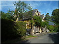
The Old School House (Bucknell)
This fantastic yellow timber-framed building was built as a farmhouse in the early 17th century. After housing a school and shop for some time, this is now divided into two cottages.
Image: © Fabian Musto
Taken: 14 Sep 2019
0.01 miles
4
![Bucknell houses [2]](https://s1.geograph.org.uk/geophotos/06/92/39/6923921_4cde5654_120x120.jpg)
Bucknell houses [2]
The Old School House, The Causeway was built as a farmhouse, later used as a school and as a shop. Built in the early 17th century with later alterations and additions. Timber-framed with plastered and painted brick infill with some roughcast and some weatherboarded, all under a slate roof. Inside there is much exposed framing and other original features. Listed, grade II, with details at: https://historicengland.org.uk/listing/the-list/list-entry/1366995
Bucknell is a village in south Shropshire, on the River Redlake, some 6 miles east of Knighton and very near the boundaries with Wales and Herefordshire. The village has been occupied since Saxon times and there are the remains of a Norman motte castle. There is a railway station on the Heart of Wales Line.
Image: © Michael Dibb
Taken: 31 May 2021
0.01 miles
5
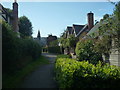
The Village of Bucknell
My most favourite view of this village is from the path that runs by the river Redlake. Closest to the camera is the Old School House, and in the distance is St. Mary's church.
Image: © Fabian Musto
Taken: 14 Sep 2019
0.01 miles
6
![Bucknell houses [3]](https://s2.geograph.org.uk/geophotos/06/92/39/6923934_ecc5ff5c_120x120.jpg)
Bucknell houses [3]
Bucknell Hall, The Causeway, was built as a farmhouse. Erected in the early 19th century with later alterations and additions. Constructed of red brick under a slate roof. Inside there is a fine oak staircase. Listed, grade II, with details at: https://historicengland.org.uk/listing/the-list/list-entry/1054988
Image: © Michael Dibb
Taken: 31 May 2021
0.02 miles
7
![Bucknell ways [2]](https://s3.geograph.org.uk/geophotos/06/92/39/6923915_a7a6ddaf_120x120.jpg)
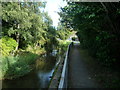
Bucknell ways [2]
The Causeway follows the River Redlake as it flows through the village.
Bucknell is a village in south Shropshire, on the River Redlake, some 6 miles east of Knighton and very near the boundaries with Wales and Herefordshire. The village has been occupied since Saxon times and there are the remains of a Norman motte castle. There is a railway station on the Heart of Wales Line.
Image: © Michael Dibb
Taken: 31 May 2021
0.02 miles
8
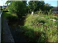
The River Redlake (Bucknell)
This is the main river that passes through the village.
Image: © Fabian Musto
Taken: 14 Sep 2019
0.03 miles
10
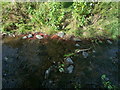
The River Redlake (Bucknell)
This is the main river that passes through the village. You can see why this river is called "Redlake", because some of the parts of the river are red.
Image: © Fabian Musto
Taken: 14 Sep 2019
0.03 miles