IMAGES TAKEN NEAR TO
Hope Bowdler, CHURCH STRETTON, SY6 7ES
Introduction
This page details the photographs taken nearby to SY6 7ES by members of the Geograph project.
The Geograph project started in 2005 with the aim of publishing, organising and preserving representative images for every square kilometre of Great Britain, Ireland and the Isle of Man.

There are currently over 7.5m images from over14,400 individuals and you can help contribute to the project by visiting https://www.geograph.org.uk
Image Map
Images are licensed for reuse under creativecommons.org/licenses/by-sa/2.0
Notes
- Clicking on the map will re-center to the selected point.
- The higher the marker number, the further away the image location is from the centre of the postcode.
Image Listing (59 Images Found)
Images are licensed for reuse under creativecommons.org/licenses/by-sa/2.0
Image
Details
Distance
3
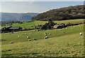
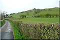
Grazing sheep at the edge of Church Stretton
Viewed from near the B4371. The Gaer Stone http://www.geograph.org.uk/photo/3875620 is in the distance.
Image: © Jaggery
Taken: 29 Oct 2013
0.04 miles
4
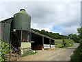
Track past Gaerstones Farm
The farmhouse is a little bit further on to the right, but these are the main farm buildings.
Image: © Bill Boaden
Taken: 19 Jun 2016
0.05 miles
5
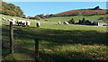
Towards Gaerstones Farm
This bridleway heads towards and through the farm. A footpath to the right, ahead of us, climbs the hill towards the Gaerstone itself, a prominent rock outcrop on the skyline.
Image: © Graham Horn
Taken: 12 May 2013
0.07 miles

8
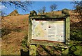
Information board at Hope Bowdler Hill
This information board is on the western edge of the hill, near the Gaer Stone.
Hope Bowdler Hill, 426 metres (1397 feet), is part of the Shropshire Hills near Church Stretton.
Image: © Mat Fascione
Taken: 26 Mar 2022
0.09 miles
9
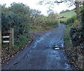
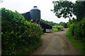
Access road to Gaerstone Farm and Cwms Farm near Church Stretton
From the B4371. Though the location is in Shropshire, England, about 14km (c9 miles)
east of the Welsh border, both farm names have Welsh language elements.
Image: © Jaggery
Taken: 29 Oct 2013
0.11 miles
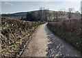
10

Track and bridleway near Helmeth Hill
Image: © Mat Fascione
Taken: 26 Mar 2022
0.11 miles