IMAGES TAKEN NEAR TO
Darby Lane, CHURCH STRETTON, SY6 7DT
Introduction
This page details the photographs taken nearby to Darby Lane, SY6 7DT by members of the Geograph project.
The Geograph project started in 2005 with the aim of publishing, organising and preserving representative images for every square kilometre of Great Britain, Ireland and the Isle of Man.

There are currently over 7.5m images from over14,400 individuals and you can help contribute to the project by visiting https://www.geograph.org.uk
Image Map
Images are licensed for reuse under creativecommons.org/licenses/by-sa/2.0
Notes
- Clicking on the map will re-center to the selected point.
- The higher the marker number, the further away the image location is from the centre of the postcode.
Image Listing (24 Images Found)
Images are licensed for reuse under creativecommons.org/licenses/by-sa/2.0
Image
Details
Distance
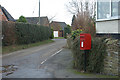
1
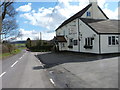
The Plough Inn
The Plough Inn at Wall under Heywood.
Image: © James Allan
Taken: 30 Mar 2016
0.01 miles
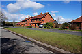
2
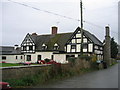
Hall Farm
The old half timber framed farmhouse in Wall-under-Heywood.
Image: © David Stowell
Taken: 14 Nov 2006
0.04 miles
3
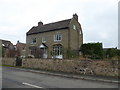
House in Wall under Heywood
Handsome place. They don't build them like that any more.
Image: © Jeremy Bolwell
Taken: 25 Nov 2018
0.12 miles
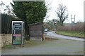
4
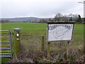
At the edge of the village
A great parish information board, lovely to see and informative.
Image: © Jeremy Bolwell
Taken: 25 Nov 2018
0.13 miles
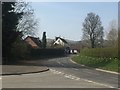
5
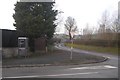
B4371, Wall Under Heywood
A bus shelter and telephone box on the road between Much Wenlock and Church Stretton.
Image: © Richard Webb
Taken: 27 Dec 2016
0.13 miles
6
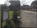
Rushbury parish map, Wall
There is some parking here, the telephone box has now gone.
Image: © Richard Webb
Taken: 1 Apr 2019
0.13 miles