IMAGES TAKEN NEAR TO
Alison Drive, CHURCH STRETTON, SY6 7AU
Introduction
This page details the photographs taken nearby to Alison Drive, SY6 7AU by members of the Geograph project.
The Geograph project started in 2005 with the aim of publishing, organising and preserving representative images for every square kilometre of Great Britain, Ireland and the Isle of Man.

There are currently over 7.5m images from over14,400 individuals and you can help contribute to the project by visiting https://www.geograph.org.uk
Image Map
Images are licensed for reuse under creativecommons.org/licenses/by-sa/2.0
Notes
- Clicking on the map will re-center to the selected point.
- The higher the marker number, the further away the image location is from the centre of the postcode.
Image Listing (113 Images Found)
Images are licensed for reuse under creativecommons.org/licenses/by-sa/2.0
Image
Details
Distance
1
Roadworks on the A4371 at Church Stretton
Image: © Eirian Evans
Taken: 4 Apr 2018
0.06 miles
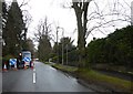
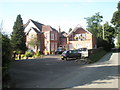
2
Entrance to South View residential home, Church Stretton
The conspicuous South View name sign contrasts with the faded
30mph speed limit signs on the surface of Sandford Avenue.
Image: © Jaggery
Taken: 29 Oct 2013
0.06 miles
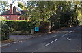
4
Entrance to Brook Meadow, Church Stretton
The cul-de-sac of Brook Meadow opens from Helmeth Road on a housing estate in the western side of the village.
Image: © Trevor Littlewood
Taken: 31 Jul 2022
0.09 miles
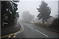
5

Sandford Avenue, Church Stretton
The B4371 Sandford Avenue heads east away from the centre of Church Stretton,
past the Hazler Road junction. The large box behind the barrier on the left is a gas governor.
Image: © Jaggery
Taken: 29 Oct 2013
0.09 miles
6
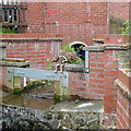
Drainage channel on Watling Street North
A stream is artificially channelled past a garden here. Someone has made a bit of a feature of it including a wooden model man sitting on the brickwork.
Image: © Graham Horn
Taken: 12 May 2013
0.10 miles
7
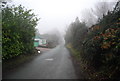
Watling Street North
Narrow lane following the route of a former Roman road.
Image: © N Chadwick
Taken: 30 Dec 2010
0.11 miles
8
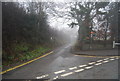
Cwms Lane
A narrow lane heading towards Caer Caradoc.
Image: © N Chadwick
Taken: 30 Dec 2010
0.12 miles
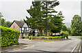
9
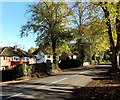
Tree-lined Sandford Avenue, Church Stretton
This is the residential part of the B4371 Sandford Avenue, east of the A49.
The greens of summer have changed to autumn colours in this late October view.
Image: © Jaggery
Taken: 29 Oct 2013
0.12 miles
10
Brookfields Guest House in Watling Street North
Image: © Basher Eyre
Taken: 7 Aug 2009
0.12 miles