IMAGES TAKEN NEAR TO
Marshbrook, CHURCH STRETTON, SY6 6RG
Introduction
This page details the photographs taken nearby to SY6 6RG by members of the Geograph project.
The Geograph project started in 2005 with the aim of publishing, organising and preserving representative images for every square kilometre of Great Britain, Ireland and the Isle of Man.

There are currently over 7.5m images from over14,400 individuals and you can help contribute to the project by visiting https://www.geograph.org.uk
Image Map
Images are licensed for reuse under creativecommons.org/licenses/by-sa/2.0
Notes
- Clicking on the map will re-center to the selected point.
- The higher the marker number, the further away the image location is from the centre of the postcode.
Image Listing (8 Images Found)
Images are licensed for reuse under creativecommons.org/licenses/by-sa/2.0
Image
Details
Distance
2
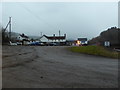
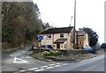
The Lazy Trout Truck Stop & Cafe near Church Stretton
Viewed from the truck stop vehicle park.
Image: © Jeremy Bolwell
Taken: 27 Jan 2017
0.05 miles
3
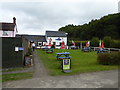
The Lazy Trout Cafe off the A49 road south of Church Stretton
Popular roadside cafe and truck stop.
Image: © Jeremy Bolwell
Taken: 16 Sep 2017
0.07 miles
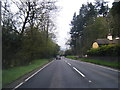
7
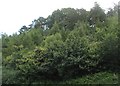
Long Wood
Woodland above the A49 by Acton Scott.
Image: © Richard Webb
Taken: 30 Jul 2009
0.21 miles
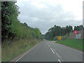
8
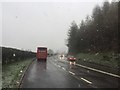
A49 near Little Stretton
Low enough for there to be few problems, but some roads were closed in South Shropshire.
Image: © Richard Webb
Taken: 4 Apr 2019
0.22 miles