1
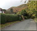
Longhills Road, Church Stretton
Part of a nearly 500 metres long dead-end road.
Image: © Jaggery
Taken: 29 Oct 2013
0.02 miles
2
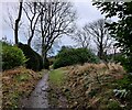
Footpath in Church Stretton
This path runs between Burway Road and Longhills Road.
Image: © Mat Fascione
Taken: 12 Dec 2021
0.05 miles
3
Burway Road electricity substation, Church Stretton
Its identifier is BURWAY ROAD S/S No 2269.
Image: © Jaggery
Taken: 29 Oct 2013
0.06 miles
4
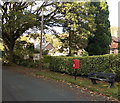
Postbox and bench, Burway Road, Church Stretton
The entrance to Belvedere Guest House http://www.geograph.org.uk/photo/4429804 is nearby.
Image: © Jaggery
Taken: 29 Oct 2013
0.06 miles
5
Burway Road in Church Stretton
Image: © Mat Fascione
Taken: 12 Dec 2021
0.06 miles
6
Entrance to Belvedere Guest House, Church Stretton
From Burway Road.
Image: © Jaggery
Taken: 29 Oct 2013
0.06 miles
7
Church Stretton from the air
This picture was taken from a Cessna 172 on a pleasure flight from Welshpool airport.
Image: © Dave Croker
Taken: 22 Jul 2008
0.07 miles
8
OS benchmark - Church Stretton, Burway Road
The rather sorry remains of an OS cutmark lie in the middle of the yellow stone in the centre of this picture. The datum line is just about visible; not so the three-legged arrow that normally supports it, although it can just about be made out, with the eye of faith, by following the lichen patches. Originally levelled at 219.529m above Ordnance Datum Newlyn.
Image: © Richard Law
Taken: 13 Dec 2014
0.08 miles
9
George V postbox in a brick pillar, Church Stretton
On the corner of Carding Mill Valley and Madeira Walk http://www.geograph.org.uk/photo/1447635
Image: © Jaggery
Taken: 29 Oct 2013
0.08 miles
10
Carding Mill Valley Road
Looking east, away from the car park, towards the town.
Image: © Jonathan Billinger
Taken: 3 Nov 2017
0.08 miles


