IMAGES TAKEN NEAR TO
Woodcote Edge, CHURCH STRETTON, SY6 6DF
Introduction
This page details the photographs taken nearby to Woodcote Edge, SY6 6DF by members of the Geograph project.
The Geograph project started in 2005 with the aim of publishing, organising and preserving representative images for every square kilometre of Great Britain, Ireland and the Isle of Man.

There are currently over 7.5m images from over14,400 individuals and you can help contribute to the project by visiting https://www.geograph.org.uk
Image Map
Images are licensed for reuse under creativecommons.org/licenses/by-sa/2.0
Notes
- Clicking on the map will re-center to the selected point.
- The higher the marker number, the further away the image location is from the centre of the postcode.
Image Listing (477 Images Found)
Images are licensed for reuse under creativecommons.org/licenses/by-sa/2.0
Image
Details
Distance
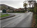
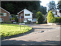
1
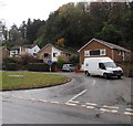
Woodcote Edge houses, Church Stretton
Houses in a cul-de-sec viewed across Ludlow Road.
Image: © Jaggery
Taken: 15 Nov 2019
0.01 miles
2
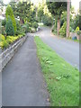
Looking down Woodmancote Edge towards Ludlow Road
Image: © Basher Eyre
Taken: 7 Aug 2009
0.02 miles
3
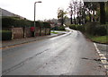
SW along Ludlow Road, Church Stretton
The broken white line is at the Woodcote Edge junction.
The Stretton Farm Road junction is on the left.
Ahead for Little Stretton.
Image: © Jaggery
Taken: 15 Nov 2019
0.02 miles
4
Into Church Stretton
Ludlow Road from Little Stretton passes a Welcome to Church Stretton sign https://www.geograph.org.uk/photo/6322725 on the right.
Image: © Jaggery
Taken: 15 Nov 2019
0.02 miles
5
Leaving Church Stretton
Looking to the southwest along Ludlow Road. On the left, the back of the
Welcome to Church Stretton sign https://www.geograph.org.uk/photo/6322725 is near the corner of Stretton Farm Road.
Image: © Jaggery
Taken: 15 Nov 2019
0.03 miles
6
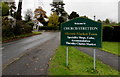
Welcome to Church Stretton Historic Market Town
The sign is alongside Ludlow Road near the corner of Stretton Farm Road.
Image: © Jaggery
Taken: 15 Nov 2019
0.03 miles
7
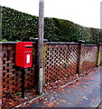
Queen Elizabeth II postbox, Ludlow Road, Church Stretton
On the left here. https://www.geograph.org.uk/photo/6335130
Image: © Jaggery
Taken: 15 Nov 2019
0.03 miles
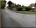
8
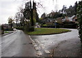
Junction of Ludlow Road and Woodcote Edge, Church Stretton
Woodcote Edge from the right joins Ludlow Road.
The Stretton Farm Road junction is ahead on the left.
Image: © Jaggery
Taken: 15 Nov 2019
0.03 miles
9
Junction of Ludlow Road and Woodcote Edge
Image: © Basher Eyre
Taken: 7 Aug 2009
0.03 miles
10
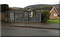
Ludlow Road electricity substation, Church Stretton
Western Power Distribution electricity substation in a locked enclosure on the right here. https://www.geograph.org.uk/photo/6322730
The substation identifier is LUDLOW ROAD S/S 840847 (12173)
Image: © Jaggery
Taken: 15 Nov 2019
0.03 miles