IMAGES TAKEN NEAR TO
Essex Road, CHURCH STRETTON, SY6 6AX
Introduction
This page details the photographs taken nearby to Essex Road, SY6 6AX by members of the Geograph project.
The Geograph project started in 2005 with the aim of publishing, organising and preserving representative images for every square kilometre of Great Britain, Ireland and the Isle of Man.

There are currently over 7.5m images from over14,400 individuals and you can help contribute to the project by visiting https://www.geograph.org.uk
Image Map
Images are licensed for reuse under creativecommons.org/licenses/by-sa/2.0
Notes
- Clicking on the map will re-center to the selected point.
- The higher the marker number, the further away the image location is from the centre of the postcode.
Image Listing (871 Images Found)
Images are licensed for reuse under creativecommons.org/licenses/by-sa/2.0
Image
Details
Distance
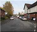
1
North along Essex Road, Church Stretton
Looking past Stretton Chambers https://www.geograph.org.uk/photo/6389063 on the right.
Image: © Jaggery
Taken: 13 Nov 2019
0.01 miles
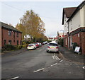
2
North along Essex Road, Church Stretton
Towards Lutwyche Road.
Image: © Jaggery
Taken: 13 Nov 2019
0.01 miles
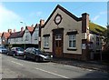
3
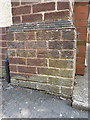
OS benchmark - Church Stretton, Club Building in Essex Road
A shallow OS cutmark in the bricks of the front face of the social club on Essex Road, originally levelled at 188.056m above Ordnance Datum Newlyn.
Image: © Richard Law
Taken: 26 Aug 2013
0.02 miles
4
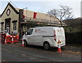
Reroofing in progress, Essex Road, Church Stretton
On November 13th 2019 an SWG Electrical van is parked
near Church Stretton & District Club during reroofing work.
Image: © Jaggery
Taken: 13 Nov 2019
0.02 miles
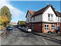
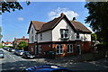
5
Church Stretton & District Club
Located in Essex Road, about 60 metres north of Sandford Road, one of the main shopping streets in Church Stretton.
Image: © Jaggery
Taken: 29 Oct 2013
0.02 miles
6
Essex Road, Church Stretton
Looking NNE from the Sandford Avenue end.
Church Stretton & District Club http://www.geograph.org.uk/photo/3724188 is in the background on the right.
Image: © Jaggery
Taken: 29 Oct 2013
0.02 miles
7
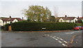
Essex Road name sign in a long hedge, Church Stretton
Near the Lutwyche Road junction.
Image: © Jaggery
Taken: 13 Nov 2019
0.02 miles
8
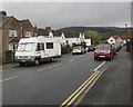
Vehicle-lined Lutwyche Road, Church Stretton
Looking to the ESE towards Essex Road.
Image: © Jaggery
Taken: 15 Nov 2019
0.02 miles
9
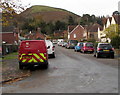
Royal Mail van CS17 parked at the eastern end of Lutwyche Road, Church Stretton
With a view of the Shropshire Hills Area of Outstanding Natural Beauty.
Image: © Jaggery
Taken: 13 Nov 2019
0.02 miles
10
Stretton Chambers and the Stretton Club, Essex Road, Church Stretton
Part of the Edwardian expansion of Church Stretton, which it was hoped would become a spa town with hordes expected to come by train, arriving at the station to the right of the photographer.
Image: © Philip Pankhurst
Taken: 15 Aug 2016
0.03 miles