IMAGES TAKEN NEAR TO
Brooksbury, CHURCH STRETTON, SY6 6AS
Introduction
This page details the photographs taken nearby to Brooksbury, SY6 6AS by members of the Geograph project.
The Geograph project started in 2005 with the aim of publishing, organising and preserving representative images for every square kilometre of Great Britain, Ireland and the Isle of Man.

There are currently over 7.5m images from over14,400 individuals and you can help contribute to the project by visiting https://www.geograph.org.uk
Image Map
Images are licensed for reuse under creativecommons.org/licenses/by-sa/2.0
Notes
- Clicking on the map will re-center to the selected point.
- The higher the marker number, the further away the image location is from the centre of the postcode.
Image Listing (719 Images Found)
Images are licensed for reuse under creativecommons.org/licenses/by-sa/2.0
Image
Details
Distance
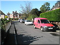
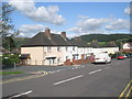
5
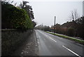
B5477, Church Stretton
The original course of the A49 until it was re-aligned around the town.
Image: © N Chadwick
Taken: 28 Dec 2010
0.04 miles
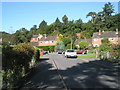
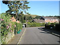
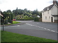
6
Looking from the junction of Brooksbury and Lutwyche Road up to the B5477
Image: © Basher Eyre
Taken: 11 Aug 2009
0.05 miles
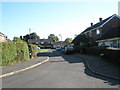
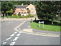
8
Junction of Lutwyche Road and Brooklands
Image: © Basher Eyre
Taken: 7 Aug 2009
0.06 miles
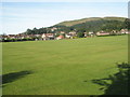
9
Junction of Churchill and Shrewsbury Roads
Image: © Basher Eyre
Taken: 9 Aug 2009
0.06 miles