IMAGES TAKEN NEAR TO
Cunnery Road, CHURCH STRETTON, SY6 6AQ
Introduction
This page details the photographs taken nearby to Cunnery Road, SY6 6AQ by members of the Geograph project.
The Geograph project started in 2005 with the aim of publishing, organising and preserving representative images for every square kilometre of Great Britain, Ireland and the Isle of Man.

There are currently over 7.5m images from over14,400 individuals and you can help contribute to the project by visiting https://www.geograph.org.uk
Image Map
Images are licensed for reuse under creativecommons.org/licenses/by-sa/2.0
Notes
- Clicking on the map will re-center to the selected point.
- The higher the marker number, the further away the image location is from the centre of the postcode.
Image Listing (598 Images Found)
Images are licensed for reuse under creativecommons.org/licenses/by-sa/2.0
Image
Details
Distance
2
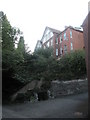
House with an extremely elevated view in Cunnery Lane
Image: © Basher Eyre
Taken: 7 Aug 2009
0.03 miles
6
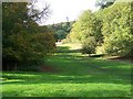
Looking back from Rectory Wood towards Cunnery Road
Image: © Basher Eyre
Taken: 7 Aug 2009
0.05 miles
7
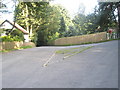
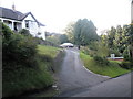
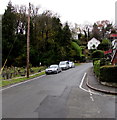
Triangular traffic island in Cunnery Lane
Having never seen one before, I've now seen two in less than a month http://www.geograph.org.uk/photo/1425981
Image: © Basher Eyre
Taken: 7 Aug 2009
0.05 miles
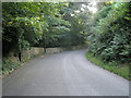
10
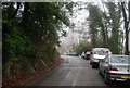
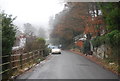
Up Cunnery Road, Church Stretton
Cunnery Road ascends away from the corner of Church Street.
Image: © Jaggery
Taken: 15 Nov 2019
0.06 miles