IMAGES TAKEN NEAR TO
Aston Rogers, Westbury, SHREWSBURY, SY5 9HE
Introduction
This page details the photographs taken nearby to SY5 9HE by members of the Geograph project.
The Geograph project started in 2005 with the aim of publishing, organising and preserving representative images for every square kilometre of Great Britain, Ireland and the Isle of Man.

There are currently over 7.5m images from over14,400 individuals and you can help contribute to the project by visiting https://www.geograph.org.uk
Image Map
Images are licensed for reuse under creativecommons.org/licenses/by-sa/2.0
Notes
- Clicking on the map will re-center to the selected point.
- The higher the marker number, the further away the image location is from the centre of the postcode.
Image Listing (6 Images Found)
Images are licensed for reuse under creativecommons.org/licenses/by-sa/2.0
Image
Details
Distance
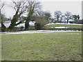
1
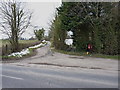
A bridleway to Bank House and Aston Rogers
Image: © Richard Law
Taken: 1 Apr 2013
0.03 miles
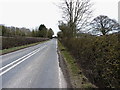
3
Damp ground in a field near Aston Rogers
Image: © Richard Law
Taken: 1 Apr 2013
0.07 miles
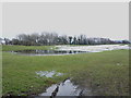
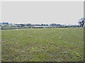
5
A footpath heads across here
You'd hardly know it except for the stile in the hedge 50 yards away; the sheep were struggling to find anything worth eating in this cold and muddy field.
Image: © Richard Law
Taken: 1 Apr 2013
0.08 miles
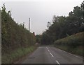
6
Sheep attempting to graze
At the end of a cold, protracted winter with little sign of fresh spring growth, the sheep and their lambs were looking for anything they could find in this field.
Image: © Richard Law
Taken: 1 Apr 2013
0.14 miles