IMAGES TAKEN NEAR TO
Bausley, Crew Green, SHREWSBURY, SY5 9BW
Introduction
This page details the photographs taken nearby to SY5 9BW by members of the Geograph project.
The Geograph project started in 2005 with the aim of publishing, organising and preserving representative images for every square kilometre of Great Britain, Ireland and the Isle of Man.

There are currently over 7.5m images from over14,400 individuals and you can help contribute to the project by visiting https://www.geograph.org.uk
Image Map (Loading...)


Getting Data...Please wait
Leaflet Map data © OpenStreetMap
Images are licensed for reuse under creativecommons.org/licenses/by-sa/2.0
Notes
- Clicking on the map will re-center to the selected point.
- The higher the marker number, the further away the image location is from the centre of the postcode.
Image Listing (6 Images Found)
Images are licensed for reuse under creativecommons.org/licenses/by-sa/2.0
Image
Details
Distance
1
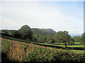
Farmland near Quarry House
Breidden Hills in distance with Rodney's Pillar
Image: © John Firth
Taken: 30 Sep 2010
0.07 miles
2
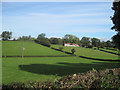
Quarry House on side of Pritchard's Hill
Image: © John Firth
Taken: 30 Sep 2010
0.14 miles
3
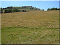
Kempster's Hill from Pritchard's Hill
Looking across Pritchard's Hill towards Kempster's Hill in the Breidden Hills.
Image: © Derek Harper
Taken: 14 Jul 2006
0.16 miles
4
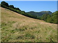
Breidden Hill from Pritchard's Hill
A view in the Breidden Hills, with Rodney's Pillar visible in the distance on Breidden Hill itself. From the footpath between Crewgreen and Brimford Wood.
Image: © Derek Harper
Taken: 14 Jul 2006
0.21 miles
5
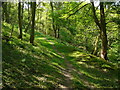
Woodland path running below Pritchard's Hill
Image: © Colin Park
Taken: 24 May 2010
0.22 miles
6
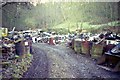
Bridleway Below Pritchard's Hill
This runs through (at the time) an unauthorised scrapyard.
Image: © Chris Andrews
Taken: Unknown
0.24 miles