IMAGES TAKEN NEAR TO
Bryn Hafren, SHREWSBURY, SY5 9BJ
Introduction
This page details the photographs taken nearby to Bryn Hafren, SY5 9BJ by members of the Geograph project.
The Geograph project started in 2005 with the aim of publishing, organising and preserving representative images for every square kilometre of Great Britain, Ireland and the Isle of Man.

There are currently over 7.5m images from over14,400 individuals and you can help contribute to the project by visiting https://www.geograph.org.uk
Image Map
Images are licensed for reuse under creativecommons.org/licenses/by-sa/2.0
Notes
- Clicking on the map will re-center to the selected point.
- The higher the marker number, the further away the image location is from the centre of the postcode.
Image Listing (9 Images Found)
Images are licensed for reuse under creativecommons.org/licenses/by-sa/2.0
Image
Details
Distance
1
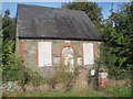
Boarded up chapel on Bulthy Road at Crew Green
Image: © John Firth
Taken: 30 Sep 2010
0.14 miles
2
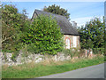
Old Chapel just outside Crew Green
On Bulthy Road
Image: © John Firth
Taken: 30 Sep 2010
0.16 miles
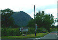
3
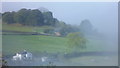
View to an old chapel in the Breidden Hills
What a spot.
Image: © Jeremy Bolwell
Taken: 12 Oct 2014
0.17 miles
4
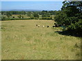
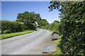
Severn valley at Crewgreen
Looking down across fields either side of the junction of Criggion Lane with the B4393 at Crewgreen.
Image: © Derek Harper
Taken: 14 Jul 2006
0.18 miles
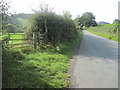
5
Criggion Lane
Layby boulders on Criggion Lane
Image: © P Gaskell
Taken: Unknown
0.18 miles
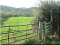
8
Path stiles in the morning mist near Crewgreen
The stiles beckon me onward through the cool morning air.
Image: © Jeremy Bolwell
Taken: 12 Oct 2014
0.20 miles
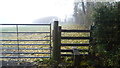
9
Lane to Bulthy
At entrance to Bausley Hill footpath just past old chapel
Image: © John Firth
Taken: 30 Sep 2010
0.24 miles