IMAGES TAKEN NEAR TO
Criggion, SHREWSBURY, SY5 9BA
Introduction
This page details the photographs taken nearby to SY5 9BA by members of the Geograph project.
The Geograph project started in 2005 with the aim of publishing, organising and preserving representative images for every square kilometre of Great Britain, Ireland and the Isle of Man.

There are currently over 7.5m images from over14,400 individuals and you can help contribute to the project by visiting https://www.geograph.org.uk
Image Map
Images are licensed for reuse under creativecommons.org/licenses/by-sa/2.0
Notes
- Clicking on the map will re-center to the selected point.
- The higher the marker number, the further away the image location is from the centre of the postcode.
Image Listing (9 Images Found)
Images are licensed for reuse under creativecommons.org/licenses/by-sa/2.0
Image
Details
Distance
1
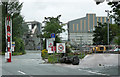
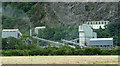
Criggion quarry, Criggion (5)
A view from the public road of the quarry machinery.
More information and a fuller view here: Image
Image: © Stephen Richards
Taken: Unknown
0.02 miles
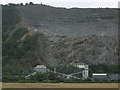
4
Criggion Quarry, Breidden Hill
Criggion Quarry, on the side of Breidden Hill. A hard rock igneous quarry, it started in 1866 and was a single face up until the 1960s. They obviously work late here, as conveying and banging sounds were still echoing from the hillside after 20:00 in the evening.
It's not that common to see such an obvious huge chunk quarried out of a hill here in the UK.
Image: © TCExplorer
Taken: 1 Aug 2024
0.16 miles
5
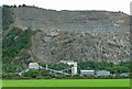
Criggion quarry, Criggion (2)
Some of the quarry machinery, behind which is a small part of the exposed north-west face of Breidden Hill, primarily an Ordovician porphyritic dolerite, comprising plagioclase feldspar, epidote, olivine, clinopyroxene, chlorite, leucoxene, iron ore, quartz, clinozoisite and allanite. Fuller view here: Image
The fruits of this quarry, up to 750,000 tons per year, are mosty used for road-stone and ready-mixed concrete.
The hill has been quarried since the early C19th. Until 1967 the face was worked by men descending from the top on ropes, to plant explosives to bring down the rock. Nowadays, rock is crushed in one of the largest items of mobile plant in the country, before being brought to the lower level by conveyor belts and gravity to be crushed further to the required size.
Information from various internet sources.
Image: © Stephen Richards
Taken: Unknown
0.18 miles
6
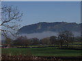
Breidden Hill surrounded in mist
Breidden Hill is a Basalt plug and is being quarried at Griggion Quarry. The large aerials in front of the hill were ULF masts that have now been removed.
Image: © John Haynes
Taken: 16 Feb 2002
0.23 miles
7
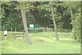
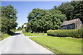
Start of track to Rodney's Pillar
Breidden Hill car park is the start of the walk to Rodney's Pillar. The track is not a public footpath adnd, as a consequence, is not open on a Tuesday.
Image: © John Firth
Taken: 15 May 2008
0.23 miles
9
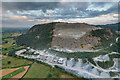
Criggion quarry, Criggion (1)
The sheer, exposed north-west face of Breidden Hill, primarily an Ordovician porphyritic dolerite, comprising plagioclase feldspar, epidote, olivine, clinopyroxene, chlorite, leucoxene, iron ore, quartz, clinozoisite and allanite.
The fruits of this quarry, up to 750,000 tons per year, are mostly used for road-stone and ready-mixed concrete.
The hill has been quarried since the early C19th. Until 1967 the face was worked by men descending from the top on ropes, to plant explosives to bring down the rock. Nowadays, rock is crushed in one of the largest items of mobile plant in the country, before being brought to the lower level by conveyor belts and gravity to be crushed further to the required size (Image]).
Information from various internet sources.
Image: © Stephen Richards
Taken: Unknown
0.24 miles