IMAGES TAKEN NEAR TO
Ratlinghope, SHREWSBURY, SY5 0SS
Introduction
This page details the photographs taken nearby to SY5 0SS by members of the Geograph project.
The Geograph project started in 2005 with the aim of publishing, organising and preserving representative images for every square kilometre of Great Britain, Ireland and the Isle of Man.

There are currently over 7.5m images from over14,400 individuals and you can help contribute to the project by visiting https://www.geograph.org.uk
Image Map (Loading...)


Getting Data...Please wait
Leaflet Map data © OpenStreetMap
Images are licensed for reuse under creativecommons.org/licenses/by-sa/2.0
Notes
- Clicking on the map will re-center to the selected point.
- The higher the marker number, the further away the image location is from the centre of the postcode.
Image Listing (5 Images Found)
Images are licensed for reuse under creativecommons.org/licenses/by-sa/2.0
Image
Details
Distance
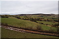
1
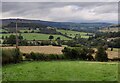
River East Onny valley at Bridges
This valley lies between the high ground of the Stiperstones and the Long Mynd.
Image: © Mat Fascione
Taken: 26 Sep 2021
0.15 miles
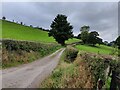
3
Across the valley towards Coppice Farm
From the northern end of Adstone Hill, looking eastwards(ish) to the slopes of the Long Mynd and Coppice Farm.
Image: © Richard Law
Taken: 26 Aug 2012
0.17 miles
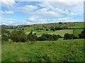
5
Muddy farm track leading down off the moors
On the route from Pole Bank down to Coates, offering pleasant views over to the Long Mynd.
Image: © Bill Boaden
Taken: 13 Mar 2009
0.23 miles