IMAGES TAKEN NEAR TO
The Bog, Minsterley, SHREWSBURY, SY5 0NH
Introduction
This page details the photographs taken nearby to SY5 0NH by members of the Geograph project.
The Geograph project started in 2005 with the aim of publishing, organising and preserving representative images for every square kilometre of Great Britain, Ireland and the Isle of Man.

There are currently over 7.5m images from over14,400 individuals and you can help contribute to the project by visiting https://www.geograph.org.uk
Image Map (Loading...)


Getting Data...Please wait
Leaflet Map data © OpenStreetMap
Images are licensed for reuse under creativecommons.org/licenses/by-sa/2.0
Notes
- Clicking on the map will re-center to the selected point.
- The higher the marker number, the further away the image location is from the centre of the postcode.
Image Listing (9 Images Found)
Images are licensed for reuse under creativecommons.org/licenses/by-sa/2.0
Image
Details
Distance
1
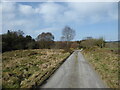
Rural track near The Bog
Leading to who knows where.
Image: © Jeremy Bolwell
Taken: 31 Mar 2021
0.12 miles
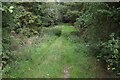
3
Footbridge and path
A footpath leaving the track near the field centre
Image: © John Poyser
Taken: 13 Nov 2007
0.14 miles
4
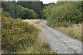
Track from The Bog towards Ritton Farm
Image: © David Martin
Taken: 15 Sep 2022
0.14 miles
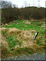
5
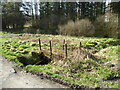
Old footbridge beside the track
Slightly redundant I think.
Image: © Jeremy Bolwell
Taken: 31 Mar 2021
0.18 miles
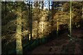
6
Track into woods near Ritton Castle
The signed path clearly follows this track into the woods, rather than the line slightly to the north marked on the OS map.
Image: © David Martin
Taken: 15 Sep 2022
0.18 miles
7
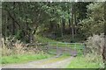
Gate into woodland south of Ritton Place
Image: © David Martin
Taken: 15 Sep 2022
0.18 miles
8
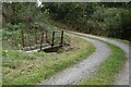
Separate footbridge beside the track to Ritton Farm
Image: © David Martin
Taken: 15 Sep 2022
0.20 miles
9
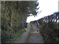
On a track beside the forestry plantation
Walkers progress along deep in conversation.
Image: © Jeremy Bolwell
Taken: 31 Mar 2021
0.24 miles