IMAGES TAKEN NEAR TO
Round Hill, SHREWSBURY, SY5 0LE
Introduction
This page details the photographs taken nearby to Round Hill, SY5 0LE by members of the Geograph project.
The Geograph project started in 2005 with the aim of publishing, organising and preserving representative images for every square kilometre of Great Britain, Ireland and the Isle of Man.

There are currently over 7.5m images from over14,400 individuals and you can help contribute to the project by visiting https://www.geograph.org.uk
Image Map (Loading...)


Getting Data...Please wait
Leaflet Map data © OpenStreetMap
Images are licensed for reuse under creativecommons.org/licenses/by-sa/2.0
Notes
- Clicking on the map will re-center to the selected point.
- The higher the marker number, the further away the image location is from the centre of the postcode.
Image Listing (4 Images Found)
Images are licensed for reuse under creativecommons.org/licenses/by-sa/2.0
Image
Details
Distance
1
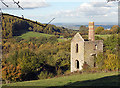
You'd almost think you were in Cornwall
Pump house of an abandoned lead mine.
Image: © Row17
Taken: 24 Oct 2010
0.18 miles
2
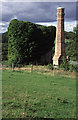
Tankerville Mine
This is Watsons Shaft seen before more recent cleaning and consolidation. The view direction is approximate based on the aerial view and direction of the lighting.
Image: © Chris Allen
Taken: 22 Aug 1998
0.25 miles
3
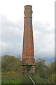
Tankerville Mine - Watson's Shaft chimney
A fine octagonal brick stack with stone detailing and a pronounced batter.
Image: © Chris Allen
Taken: 1 Nov 2014
0.25 miles
4
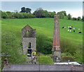
Former mine near Pennerley
Remnants of a former lead mine, a ruined engine house, dating from 1876, and a chimney looking in better condition. Grade II listed.
See also Image] and Image
Image: © Stephen Richards
Taken: 13 May 2014
0.25 miles