IMAGES TAKEN NEAR TO
Minsterley, SHREWSBURY, SY5 0LA
Introduction
This page details the photographs taken nearby to SY5 0LA by members of the Geograph project.
The Geograph project started in 2005 with the aim of publishing, organising and preserving representative images for every square kilometre of Great Britain, Ireland and the Isle of Man.

There are currently over 7.5m images from over14,400 individuals and you can help contribute to the project by visiting https://www.geograph.org.uk
Image Map
Images are licensed for reuse under creativecommons.org/licenses/by-sa/2.0
Notes
- Clicking on the map will re-center to the selected point.
- The higher the marker number, the further away the image location is from the centre of the postcode.
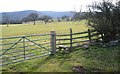
Image Listing (5 Images Found)
Images are licensed for reuse under creativecommons.org/licenses/by-sa/2.0
Image
Details
Distance
4
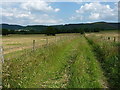
Bridleway above Venus Bank
A narrow farm track & bridleway lead the eye towards the Stiperstone ridge above Crowsnest Dingle, whose white cottages catch the afternoon sunlight.
Image: © Richard Law
Taken: 13 Jul 2013
0.19 miles
5
Path looking east
The hills in the distance are the northern end of the Stiperstones
Image: © Dave Croker
Taken: 5 Mar 2008
0.21 miles