IMAGES TAKEN NEAR TO
Hope Park, SHREWSBURY, SY5 0HQ
Introduction
This page details the photographs taken nearby to Hope Park, SY5 0HQ by members of the Geograph project.
The Geograph project started in 2005 with the aim of publishing, organising and preserving representative images for every square kilometre of Great Britain, Ireland and the Isle of Man.

There are currently over 7.5m images from over14,400 individuals and you can help contribute to the project by visiting https://www.geograph.org.uk
Image Map
Images are licensed for reuse under creativecommons.org/licenses/by-sa/2.0
Notes
- Clicking on the map will re-center to the selected point.
- The higher the marker number, the further away the image location is from the centre of the postcode.
Image Listing (26 Images Found)
Images are licensed for reuse under creativecommons.org/licenses/by-sa/2.0
Image
Details
Distance
2
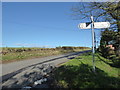
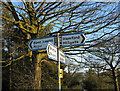
Scene at the crossroads
A sign and some upland.
Image: © Jeremy Bolwell
Taken: 27 Oct 2019
0.07 miles
3
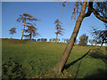
Hill pasture near Hope Park
A view to the distinctive tump of Bromlow Callow.
Image: © Jonathan Billinger
Taken: 3 Jan 2008
0.09 miles
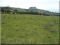
4
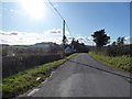
View at the crossroads
Looking southwards towards Corndon Hill on an autumn day.
Image: © Jeremy Bolwell
Taken: 27 Oct 2019
0.09 miles
5
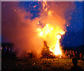
Beacon ablaze!
Part of the Hope Diamond Jubilee celebrations.
Image: © Dave Croker
Taken: 4 Jun 2012
0.10 miles
7
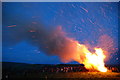
Wind helps the Jubilee Beacon catch fire
Image: © Dave Croker
Taken: 4 Jun 2012
0.10 miles
8

Jubilee Beacon near Bromlow Callow
Part of the Hope Diamond Jubilee celebrations
Image: © Dave Croker
Taken: 4 Jun 2012
0.11 miles
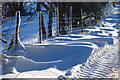
9
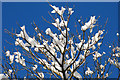
Tree top snow
The last of the snow that fell on December 30th 2009.
Image: © Dave Croker
Taken: 2 Jan 2010
0.11 miles