IMAGES TAKEN NEAR TO
Grimmer, Minsterley, SHREWSBURY, SY5 0DP
Introduction
This page details the photographs taken nearby to SY5 0DP by members of the Geograph project.
The Geograph project started in 2005 with the aim of publishing, organising and preserving representative images for every square kilometre of Great Britain, Ireland and the Isle of Man.

There are currently over 7.5m images from over14,400 individuals and you can help contribute to the project by visiting https://www.geograph.org.uk
Image Map (Loading...)


Getting Data...Please wait
Leaflet Map data © OpenStreetMap
Images are licensed for reuse under creativecommons.org/licenses/by-sa/2.0
Notes
- Clicking on the map will re-center to the selected point.
- The higher the marker number, the further away the image location is from the centre of the postcode.
Image Listing (4 Images Found)
Images are licensed for reuse under creativecommons.org/licenses/by-sa/2.0
Image
Details
Distance
2
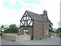
Lower Grimmer Farm
The dairy farm is almost hidden in a dip. The farm grazing is on the flood plain of the Rea Brook.
Image: © John M
Taken: 7 Jul 2007
0.09 miles
3
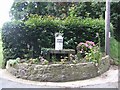
Churn at the farm entrance
Before milk tankers all milk was collected in churns from the farms. Many of the platforms at the farm entrances survive in the area.
Image: © John M
Taken: 7 Jul 2007
0.14 miles
4
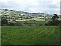
Upper Grimmer Farm
Dairy farming country close to the large creamery in Minsterley.
Image: © John M
Taken: 7 Jul 2007
0.18 miles