IMAGES TAKEN NEAR TO
Weston, SHREWSBURY, SY4 5UX
Introduction
This page details the photographs taken nearby to SY4 5UX by members of the Geograph project.
The Geograph project started in 2005 with the aim of publishing, organising and preserving representative images for every square kilometre of Great Britain, Ireland and the Isle of Man.

There are currently over 7.5m images from over14,400 individuals and you can help contribute to the project by visiting https://www.geograph.org.uk
Image Map
Images are licensed for reuse under creativecommons.org/licenses/by-sa/2.0
Notes
- Clicking on the map will re-center to the selected point.
- The higher the marker number, the further away the image location is from the centre of the postcode.
Image Listing (7 Images Found)
Images are licensed for reuse under creativecommons.org/licenses/by-sa/2.0
Image
Details
Distance
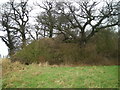
1
Weston-under-Redcastle, eastward towards Hodnet, 1990
View NE, just past the Church.
Image: © Ben Brooksbank
Taken: 26 Aug 1990
0.11 miles
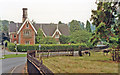
2
Junction at Weston-under-Redcastle
The road ahead leads to Hodnet. Left of the building is the entrance to Hawkstone Park.
Image: © David Weston
Taken: 21 Sep 2016
0.11 miles
3
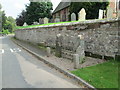
Stocks at Weston-under-Redcastle
Stocks in front of St Luke's Church.
Image: © David Weston
Taken: 21 Sep 2016
0.13 miles
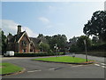
4
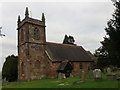
The Church of St Luke in Weston-under-Redcastle
Viewed from the south-west.
Image: © Peter Wood
Taken: 3 Dec 2016
0.13 miles
5
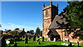
Weston under Redcastle - St Luke's Church
Image: © Colin Park
Taken: 27 Sep 2020
0.13 miles
6
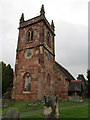
St Luke's Church, Weston-under-Redcastle
Built in 1791, of red sandstone.
Image: © David Weston
Taken: 21 Sep 2016
0.13 miles