IMAGES TAKEN NEAR TO
Petton, Burlton, SHREWSBURY, SY4 5TE
Introduction
This page details the photographs taken nearby to SY4 5TE by members of the Geograph project.
The Geograph project started in 2005 with the aim of publishing, organising and preserving representative images for every square kilometre of Great Britain, Ireland and the Isle of Man.

There are currently over 7.5m images from over14,400 individuals and you can help contribute to the project by visiting https://www.geograph.org.uk
Image Map
Images are licensed for reuse under creativecommons.org/licenses/by-sa/2.0
Notes
- Clicking on the map will re-center to the selected point.
- The higher the marker number, the further away the image location is from the centre of the postcode.
Image Listing (13 Images Found)
Images are licensed for reuse under creativecommons.org/licenses/by-sa/2.0
Image
Details
Distance
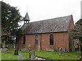
1
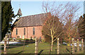
Petton Church
A small church in a field dating back to 1727
Image: © Mike Jackson
Taken: 11 Feb 2007
0.01 miles
2
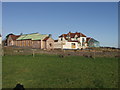
Church Farm house and stables
The house has been recently refurbished and the stables are newly built.
Image: © John Haynes
Taken: 11 Dec 2007
0.03 miles
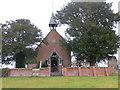
5
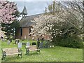
The Church of St Raphael and St Isidore at Petton
Viewed from the south-east.
Image: © Peter Wood
Taken: 3 Dec 2016
0.06 miles
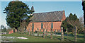
6
The Church of St Raphael and St Isidore at Petton
Viewed from the west.
Image: © Peter Wood
Taken: 3 Dec 2016
0.06 miles
7
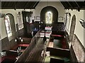
Petton Church
St Raphael and St Isodore church Petton
Image: © Mike Jackson
Taken: 11 Feb 2007
0.06 miles
8
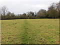
Footpath across a field from Petton Church to Petton Hall
Looking north-westward.
Image: © Peter Wood
Taken: 3 Dec 2016
0.08 miles
9
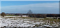
Shropshire landscape seen from Petton Church
View across Petton Park
Image: © Mike Jackson
Taken: 11 Feb 2007
0.10 miles
10
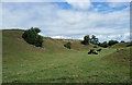
Burial mound, Petton
An example of a burial mound (bowl barrow) dating probably from the Bronze Age. It is a scheduled monument. Information from Shropshire Council.
Disgracefully, the cows were sprawling about, showing scant regard for, or appreciation of, this historic site.
Image: © Stephen Richards
Taken: Unknown
0.11 miles