IMAGES TAKEN NEAR TO
Ash Grove, SHREWSBURY, SY4 5RW
Introduction
This page details the photographs taken nearby to Ash Grove, SY4 5RW by members of the Geograph project.
The Geograph project started in 2005 with the aim of publishing, organising and preserving representative images for every square kilometre of Great Britain, Ireland and the Isle of Man.

There are currently over 7.5m images from over14,400 individuals and you can help contribute to the project by visiting https://www.geograph.org.uk
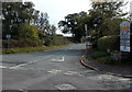
Image Map
Images are licensed for reuse under creativecommons.org/licenses/by-sa/2.0
Notes
- Clicking on the map will re-center to the selected point.
- The higher the marker number, the further away the image location is from the centre of the postcode.
Image Listing (20 Images Found)
Images are licensed for reuse under creativecommons.org/licenses/by-sa/2.0
Image
Details
Distance
1
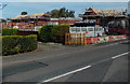
House construction near the eastern edge of Wem
Viewed across Soulton Road from the corner of Church Lane in early October 2014.
Image: © Jaggery
Taken: 5 Oct 2014
0.06 miles
2
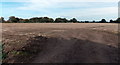
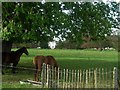
Brown field near Wem
Viewed from this http://www.geograph.org.uk/photo/4201011 Church Lane entrance looking towards Soulton Road in early October 2014.
Image: © Jaggery
Taken: 5 Oct 2014
0.07 miles
3
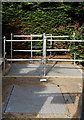
Glimpse inside the compound, Soulton Road sewage pumping station, Wem
Viewed through the gap in the gates here. http://www.geograph.org.uk/photo/4201217
Image: © Jaggery
Taken: 5 Oct 2014
0.09 miles
4

Soulton Road sewage pumping station, Wem
The Severn Trent Water site is opposite the Church Lane junction.
The yellow notice warns of overhead cables, 3 metres above ground level.
http://www.geograph.org.uk/photo/4201222 to a closer view.
Image: © Jaggery
Taken: 5 Oct 2014
0.09 miles
5
Kill your speed on Church Lane near Wem
This sign is oddly placed. It is still within Wem's 30mph speed limit, yet despite the Kill your speed message, the speed limit increases to the National Speed Limit just beyond the bend ahead.
In any case, vegetation obscures the sign.
Image: © Jaggery
Taken: 5 Oct 2014
0.10 miles
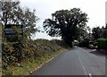
6
Northern end of Church Lane, Wem
Church Lane heads SSE towards the hamlet of Aston, away from the B5065 Soulton Road,
The Wem boundary sign is on the right. A small sign on the left shows Road liable to flooding.
Image: © Jaggery
Taken: 5 Oct 2014
0.10 miles
8

Speed check area, Soulton Road, Wem
Near the corner of Church Lane and the Wem boundary sign. http://www.geograph.org.uk/photo/4235522
Image: © Jaggery
Taken: 5 Oct 2014
0.11 miles
9
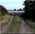
Ungated field entrance from Church Lane near Wem
Opposite this gate http://www.geograph.org.uk/photo/4201007 to a Wem Walk.
Image: © Jaggery
Taken: 5 Oct 2014
0.15 miles
10
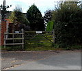
Gate to a Wem Walk
Viewed across Church Lane near the eastern edge of Wem. A small round notice on a post shows Wem Walks. This route is through the edge of Wem Cricket Club's (Wem CC) ground.
Image: © Jaggery
Taken: 5 Oct 2014
0.16 miles