IMAGES TAKEN NEAR TO
Edstaston, Wem, SHREWSBURY, SY4 5RQ
Introduction
This page details the photographs taken nearby to SY4 5RQ by members of the Geograph project.
The Geograph project started in 2005 with the aim of publishing, organising and preserving representative images for every square kilometre of Great Britain, Ireland and the Isle of Man.

There are currently over 7.5m images from over14,400 individuals and you can help contribute to the project by visiting https://www.geograph.org.uk
Image Map
Images are licensed for reuse under creativecommons.org/licenses/by-sa/2.0
Notes
- Clicking on the map will re-center to the selected point.
- The higher the marker number, the further away the image location is from the centre of the postcode.
Image Listing (6 Images Found)
Images are licensed for reuse under creativecommons.org/licenses/by-sa/2.0
Image
Details
Distance

2
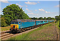
Train near Prees
Arriva Train heading south near Prees station.
Image: © Wayland Smith
Taken: 4 Jun 2011
0.06 miles
4
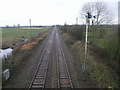
Railway to Wem
The town of Wem is 3 squares down the line.
Image: © Michael Patterson
Taken: 22 Feb 2007
0.14 miles
5
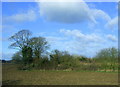
Bridleway and footpath at the field edge
Busy with birds of prey as I passed.
Image: © Jeremy Bolwell
Taken: 8 Jul 2021
0.14 miles
6
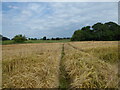
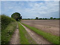
Footpath line across a cornfield
Across I go, putting up the odd pheasant.
Image: © Jeremy Bolwell
Taken: 8 Jul 2021
0.24 miles