IMAGES TAKEN NEAR TO
Edstaston, Wem, SHREWSBURY, SY4 5RF
Introduction
This page details the photographs taken nearby to SY4 5RF by members of the Geograph project.
The Geograph project started in 2005 with the aim of publishing, organising and preserving representative images for every square kilometre of Great Britain, Ireland and the Isle of Man.

There are currently over 7.5m images from over14,400 individuals and you can help contribute to the project by visiting https://www.geograph.org.uk
Image Map
Images are licensed for reuse under creativecommons.org/licenses/by-sa/2.0
Notes
- Clicking on the map will re-center to the selected point.
- The higher the marker number, the further away the image location is from the centre of the postcode.
Image Listing (10 Images Found)
Images are licensed for reuse under creativecommons.org/licenses/by-sa/2.0
Image
Details
Distance
1
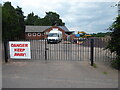
Edstaston village hall
The sign refers to the construction work currently going on I assume rather than the dangerous activities that are conducted at the village hall.
I strolled past and wondered if the locals took part in paintball combat competitions, broadsword combat training sessions, axe throwing target practice, flamethrower testing, improvised explosive device defusing, naked hot room yoga or sundry other dangerous pastimes...? Where do I sign up?
Image: © Jeremy Bolwell
Taken: 8 Jul 2021
0.10 miles
3
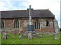
War memorial at Edstaston
Another memorial with too many names.
Image: © Jeremy Bolwell
Taken: 8 Jul 2021
0.10 miles
4
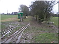
Old Canal Bank
This banking is the remains of the former Prees branch of the Shropshire Union Canal.
Image: © Michael Patterson
Taken: 22 Feb 2007
0.10 miles
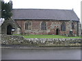
5
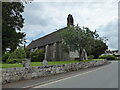
Village church at Edstaston
St Mary the Virgin.
Image: © Jeremy Bolwell
Taken: 8 Jul 2021
0.11 miles
6
St Mary the Virgin
St Mary the Virgin Church in Edstaston was founded in 1150.
Image: © Michael Patterson
Taken: 22 Feb 2007
0.11 miles
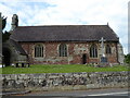
7
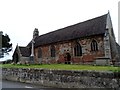
St Mary the Virgin, Edstaston
C12. The east wall was rebuilt around 1300. The south porch seen from this side dates from 1710. The church was restored in 1882 by G.H. Birch. See http://en.wikipedia.org/wiki/St_Mary's_Church,_Edstaston
Image: © Bikeboy
Taken: 10 Apr 2014
0.12 miles