IMAGES TAKEN NEAR TO
Bazeley Way, SHREWSBURY, SY4 5QN
Introduction
This page details the photographs taken nearby to Bazeley Way, SY4 5QN by members of the Geograph project.
The Geograph project started in 2005 with the aim of publishing, organising and preserving representative images for every square kilometre of Great Britain, Ireland and the Isle of Man.

There are currently over 7.5m images from over14,400 individuals and you can help contribute to the project by visiting https://www.geograph.org.uk
Image Map
Images are licensed for reuse under creativecommons.org/licenses/by-sa/2.0
Notes
- Clicking on the map will re-center to the selected point.
- The higher the marker number, the further away the image location is from the centre of the postcode.
Image Listing (35 Images Found)
Images are licensed for reuse under creativecommons.org/licenses/by-sa/2.0
Image
Details
Distance
1
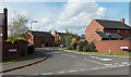
Bazeley Way, Wem
Cul-de-sac viewed across Whitchurch Road.
Image: © Jaggery
Taken: 5 Oct 2014
0.01 miles
2
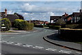
Love Lane, Wem
Viewed from Whitchurch Road. Love Lane, though not a through route for vehicles, leads to a public footpath to Creamore.
Image: © Jaggery
Taken: 5 Oct 2014
0.05 miles
3
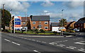
Willmott Meadow, Wem
A Taylor Wimpey development of 3, 4 and 5 bedroom detached houses on the east
side of Whitchurch Road. The street name sign on the right shows Oakley Meadow.
Image: © Jaggery
Taken: 5 Oct 2014
0.05 miles
4
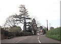
Northern boundary of Wem
The B5476 Whitchurch Road reaches the northern boundary of Wem, a small market town in north Shropshire. Alongside the boundary sign is a notice showing a depiction of a camera and the text Community Concern Route Enforcement.
Image: © Jaggery
Taken: 5 Oct 2014
0.06 miles
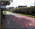
5
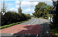
End of the 30mph speed limit at the northern edge of Wem
Viewed along Whitchurch Road. The 30mph speed limit in Wem increases to the National Speed Limit ahead. The grey back of the Wem boundary sign http://www.geograph.org.uk/photo/4198034 is on the right.
Image: © Jaggery
Taken: 5 Oct 2014
0.07 miles
6
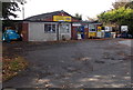
J.Jenkins Spares Ltd in Wem
Viewed across Love Lane, near the Whitchurch Road junction.
Image: © Jaggery
Taken: 5 Oct 2014
0.07 miles
7
Fismes Way, Wem
Viewed across Whitchurch Road. When I saw the street name sign, I wondered who or what a fiz-mess is. Later, I saw this boundary sign http://www.geograph.org.uk/photo/4194154 which shows that Fismes (pronounced Feem) in France is Wem's twin town.
Image: © Jaggery
Taken: 5 Oct 2014
0.08 miles
9
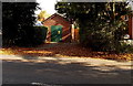
Haybarn electricity substation, Wem
Set back from the east side of Whitchurch Road. The identifier is 09-5129-23G HAYBARN SUBSTATION.
There is a Manweb Danger of Death - Keep Out yellow sign on a door.
Image: © Jaggery
Taken: 5 Oct 2014
0.08 miles
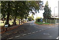
10
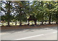
Tree-lined edge of Whitchurch Road Cemetery, Wem
This is the eastern side of the cemetery. Some sources refer to it as Love Lane Cemetery.
Image: © Jaggery
Taken: 5 Oct 2014
0.10 miles