IMAGES TAKEN NEAR TO
Aston, Wem, SHREWSBURY, SY4 5QJ
Introduction
This page details the photographs taken nearby to SY4 5QJ by members of the Geograph project.
The Geograph project started in 2005 with the aim of publishing, organising and preserving representative images for every square kilometre of Great Britain, Ireland and the Isle of Man.

There are currently over 7.5m images from over14,400 individuals and you can help contribute to the project by visiting https://www.geograph.org.uk
Image Map
Images are licensed for reuse under creativecommons.org/licenses/by-sa/2.0
Notes
- Clicking on the map will re-center to the selected point.
- The higher the marker number, the further away the image location is from the centre of the postcode.
Image Listing (4 Images Found)
Images are licensed for reuse under creativecommons.org/licenses/by-sa/2.0
Image
Details
Distance
1
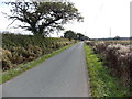
Road through Brockhurst
Rural north Shropshire, viewed from near this http://www.geograph.org.uk/photo/4195928 boundary sign.
Image: © Jaggery
Taken: 5 Oct 2014
0.10 miles
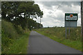
3
Brockhurst boundary sign viewed from Aston
I was surprised to see this boundary sign because the Philip's Street Atlas of Shropshire I was using does not show Brockhurst in its index. There is an entry for Lee Brockhurst, but that is nearly 2km ahead.
Image: © Jaggery
Taken: 5 Oct 2014
0.19 miles
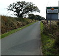
4
Kill your speed in Aston
The message on the boundary sign at the SE edge of Aston is the same
as on the Brockhurst boundary sign http://www.geograph.org.uk/photo/4195928 on the back of this one.
Image: © Jaggery
Taken: 5 Oct 2014
0.19 miles