IMAGES TAKEN NEAR TO
Besford Wood, Preston Brockhurst, SHREWSBURY, SY4 5QE
Introduction
This page details the photographs taken nearby to SY4 5QE by members of the Geograph project.
The Geograph project started in 2005 with the aim of publishing, organising and preserving representative images for every square kilometre of Great Britain, Ireland and the Isle of Man.

There are currently over 7.5m images from over14,400 individuals and you can help contribute to the project by visiting https://www.geograph.org.uk
Image Map
Images are licensed for reuse under creativecommons.org/licenses/by-sa/2.0
Notes
- Clicking on the map will re-center to the selected point.
- The higher the marker number, the further away the image location is from the centre of the postcode.
Image Listing (6 Images Found)
Images are licensed for reuse under creativecommons.org/licenses/by-sa/2.0
Image
Details
Distance
1
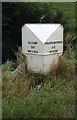
Old Milepost by the A49, Bridleway Gate
Salop iron T-post by the A49, in parish of Moreton Corbet and Lee Brockhurst (North Shropshire District), Bridleway Gate, Moston Turn.
Lost since 1990
Inscription reads:-
: SALOP / 10 / MILES : : WHITCHURCH / 9½ / MILES :
Grade II listed.
List Entry Number: 1366799 https://historicengland.org.uk/listing/the-list/list-entry/1366799
Milestone Society National ID: SA_WCSB10
Image: © Milestone Society
Taken: Unknown
0.12 miles
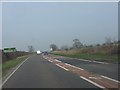
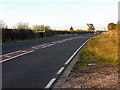
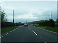
6
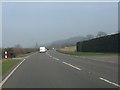
A49 at the turning for Bridleway Gate
Image: © Peter Whatley
Taken: 23 Mar 2012
0.24 miles