IMAGES TAKEN NEAR TO
Shrewsbury Road, SHREWSBURY, SY4 5PW
Introduction
This page details the photographs taken nearby to Shrewsbury Road, SY4 5PW by members of the Geograph project.
The Geograph project started in 2005 with the aim of publishing, organising and preserving representative images for every square kilometre of Great Britain, Ireland and the Isle of Man.

There are currently over 7.5m images from over14,400 individuals and you can help contribute to the project by visiting https://www.geograph.org.uk
Image Map
Images are licensed for reuse under creativecommons.org/licenses/by-sa/2.0
Notes
- Clicking on the map will re-center to the selected point.
- The higher the marker number, the further away the image location is from the centre of the postcode.
Image Listing (3 Images Found)
Images are licensed for reuse under creativecommons.org/licenses/by-sa/2.0
Image
Details
Distance
1

Old Milestone by the B5476, west of Trench Hall, Wem Rural parish
Stone post by the B5476, in parish of Wem Rural (North Shropshire District), West of Trench Hall; Tilley Park, behind current broken Milepost.
Cast iron Milepost only is Grade II listed.
Image
Milestone Society National ID: SA_WMSB01a
Image: © Milestone Society
Taken: Unknown
0.10 miles
2
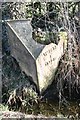
Old Milepost by the B5476, west of Trench Hall, Wem Rural parish
Cast iron post by the B5476, in parish of Wem Rural (North Shropshire District), West of Trench Hall; Tilley Park; North of track to Upper Trench, by the road, on East side of road. Salop iron T-post, erected by the County Council in the 19th/20th century. Stands in front of an earlier Milestone Image
Inscription reads:-
: SALOP / 9 / MILES : : WEM / 1 / MILE :
Grade II listed.
List Entry Number: 1236503 https://historicengland.org.uk/listing/the-list/list-entry/1236503
Milestone Society National ID: SA_WMSB01
Image: © A Reade/J Higgins
Taken: 1 Jun 2006
0.10 miles