IMAGES TAKEN NEAR TO
Shrewsbury Road, SHREWSBURY, SY4 5PP
Introduction
This page details the photographs taken nearby to Shrewsbury Road, SY4 5PP by members of the Geograph project.
The Geograph project started in 2005 with the aim of publishing, organising and preserving representative images for every square kilometre of Great Britain, Ireland and the Isle of Man.

There are currently over 7.5m images from over14,400 individuals and you can help contribute to the project by visiting https://www.geograph.org.uk
Image Map
Images are licensed for reuse under creativecommons.org/licenses/by-sa/2.0
Notes
- Clicking on the map will re-center to the selected point.
- The higher the marker number, the further away the image location is from the centre of the postcode.
Image Listing (5 Images Found)
Images are licensed for reuse under creativecommons.org/licenses/by-sa/2.0
Image
Details
Distance
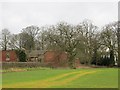
1
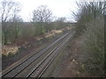
Railway line and farm buildings near to Lyons Wood
This is the Welsh Marches line running between Shrewsbury and Crewe. Originally opened in 1858.
Image: © Bikeboy
Taken: 10 Apr 2014
0.13 miles
2
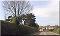
Houses on bend between B5476 and the railway
Image: © John Firth
Taken: 13 Apr 2014
0.15 miles
3
Ruins, Shooter's Hill
Ruined farm buildings near Clive.
Image: © Richard Webb
Taken: 17 Feb 2014
0.19 miles