IMAGES TAKEN NEAR TO
Tilley, Wem, SHREWSBURY, SY4 5PD
Introduction
This page details the photographs taken nearby to SY4 5PD by members of the Geograph project.
The Geograph project started in 2005 with the aim of publishing, organising and preserving representative images for every square kilometre of Great Britain, Ireland and the Isle of Man.

There are currently over 7.5m images from over14,400 individuals and you can help contribute to the project by visiting https://www.geograph.org.uk
Image Map
Images are licensed for reuse under creativecommons.org/licenses/by-sa/2.0
Notes
- Clicking on the map will re-center to the selected point.
- The higher the marker number, the further away the image location is from the centre of the postcode.
Image Listing (16 Images Found)
Images are licensed for reuse under creativecommons.org/licenses/by-sa/2.0
Image
Details
Distance
1
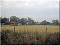
Land at the Bungalow Tilley
From Crewe railway line
Image: © John Firth
Taken: 18 Aug 2011
0.01 miles

3
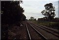
Railway at Tilley
Crossing on right of way the Whitchurch/Shrewsbury Railway lines. This looks south, away from Wem.
Image: © Chris Heaton
Taken: 17 Oct 2001
0.08 miles
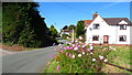
5
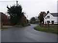
Tilley Road
The road between Tilley and Wem.
Image: © David Dixon
Taken: 1 Jun 2019
0.16 miles
6
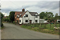
Tilley
Tilley is a small village to the south of and almost merged with Wem in North Shropshire.
Image: © David Dixon
Taken: 1 Jun 2019
0.17 miles
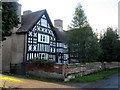
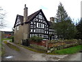
10
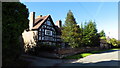
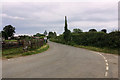
Tilley Hall near Wem
This building dates from 1613 and is one of several historic buildings along the village street.
Image: © Colin Park
Taken: 27 Sep 2020
0.20 miles