IMAGES TAKEN NEAR TO
Weston, SHREWSBURY, SY4 5LR
Introduction
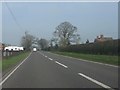
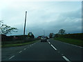
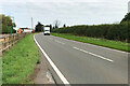
This page details the photographs taken nearby to SY4 5LR by members of the Geograph project.
The Geograph project started in 2005 with the aim of publishing, organising and preserving representative images for every square kilometre of Great Britain, Ireland and the Isle of Man.

There are currently over 7.5m images from over14,400 individuals and you can help contribute to the project by visiting https://www.geograph.org.uk
Image Map
Images are licensed for reuse under creativecommons.org/licenses/by-sa/2.0
Notes
- Clicking on the map will re-center to the selected point.
- The higher the marker number, the further away the image location is from the centre of the postcode.
Image Listing (6 Images Found)
Images are licensed for reuse under creativecommons.org/licenses/by-sa/2.0
Image
Details
Distance
3
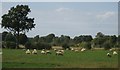
Sheep grazing
Sheep in a field just north of Linford Farm
Image: © Peter Fleming
Taken: 13 Sep 2007
0.06 miles
5
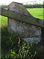
Old Milepost by the former A49, by Brook Farm, north of Weston
Salop iron T-post by the former A49, in parish of Weston under Redcastle (North Shropshire District), Brook Farm, on old road by farm entrance.
May be lost
Inscription once read:-
: (Shrewsbury / 12) : : (Whitchurch / 7½) :
Shropshire HER.
HER Number (PRN): 21071 https://www.heritagegateway.org.uk/Gateway/Results_Single.aspx?uid=MSA23625&resourceID=1015
Milestone Society National ID: SA_WCSB07
Image: © Milestone Society
Taken: Unknown
0.15 miles
