IMAGES TAKEN NEAR TO
Aston, Wem, SHREWSBURY, SY4 5JH
Introduction
This page details the photographs taken nearby to SY4 5JH by members of the Geograph project.
The Geograph project started in 2005 with the aim of publishing, organising and preserving representative images for every square kilometre of Great Britain, Ireland and the Isle of Man.

There are currently over 7.5m images from over14,400 individuals and you can help contribute to the project by visiting https://www.geograph.org.uk
Image Map
Images are licensed for reuse under creativecommons.org/licenses/by-sa/2.0
Notes
- Clicking on the map will re-center to the selected point.
- The higher the marker number, the further away the image location is from the centre of the postcode.
Image Listing (26 Images Found)
Images are licensed for reuse under creativecommons.org/licenses/by-sa/2.0
Image
Details
Distance
1

Hedge and houses in Aston
Viewed from Aston Road in a hamlet near Wem in north Shropshire.
Image: © Jaggery
Taken: 5 Oct 2014
0.01 miles
2
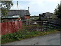
Farm buildings in Aston
Part of a hamlet near Wem in north Shropshire.
Image: © Jaggery
Taken: 5 Oct 2014
0.02 miles
3
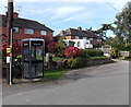
BT phonebox in Aston
In the centre of a hamlet near Wem in north Shropshire.
Image: © Jaggery
Taken: 5 Oct 2014
0.02 miles
4
Victorian cottage in Aston
At the entrance to Aston Hall Farm. The mid 19th century cottage
(with later additions and alterations) was Grade II listed in 1987.
Image: © Jaggery
Taken: 5 Oct 2014
0.06 miles
5
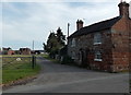
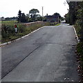
10, Aston
The cottage on the right has the simple address 10, Aston - the front door carries the number. Although a listed building it is unoccupied and pretty much derelict - perhaps it would make a good restoration project for somebody. It dates from the mid-19th century and stands by the gate to Aston Hall. The yellow sign warns of a forthcoming road closure for water works.
Image: © Stephen McKay
Taken: 6 Jul 2021
0.06 miles
6
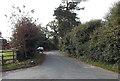
Lane from Aston towards Barkers Green
In rural north Shropshire, near Wem.
Image: © Jaggery
Taken: 5 Oct 2014
0.06 miles
7
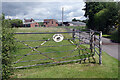
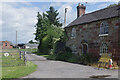
Gate to Aston Hall
The roadway to the right of the gate leads up to the timber-framed Aston Hall running alongside the River Roden. It is also a public footpath.
Image: © Stephen McKay
Taken: 6 Jul 2021
0.07 miles
8
River Roden, Aston
Looking east from Aston Bridge. The river is a tributary of the River Tern,
into which it flows at Walcot, a small village in the borough of Telford and Wrekin.
Image: © Jaggery
Taken: 5 Oct 2014
0.09 miles
9
Aston Bridge, Aston
The bridge carries the road over the River Roden http://www.geograph.org.uk/photo/4195835 in the hamlet of Aston, east of Wem in north Shropshire.
Image: © Jaggery
Taken: 5 Oct 2014
0.10 miles
10
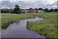
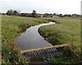
River Roden, Aston
The River Roden is formed from three streams that rise to the west of Wem and is a tributary of the River Tern, itself a tributary of the Severn. It is seen here looking downstream from the bridge at Aston with the buildings of Aston Hall in the background.
Image: © Stephen McKay
Taken: 6 Jul 2021
0.11 miles