IMAGES TAKEN NEAR TO
Station Road, SHREWSBURY, SY4 5FH
Introduction
This page details the photographs taken nearby to Station Road, SY4 5FH by members of the Geograph project.
The Geograph project started in 2005 with the aim of publishing, organising and preserving representative images for every square kilometre of Great Britain, Ireland and the Isle of Man.

There are currently over 7.5m images from over14,400 individuals and you can help contribute to the project by visiting https://www.geograph.org.uk
Image Map
Images are licensed for reuse under creativecommons.org/licenses/by-sa/2.0
Notes
- Clicking on the map will re-center to the selected point.
- The higher the marker number, the further away the image location is from the centre of the postcode.
Image Listing (62 Images Found)
Images are licensed for reuse under creativecommons.org/licenses/by-sa/2.0
Image
Details
Distance
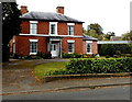
1
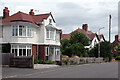
Station Road, Wem
Most small towns seem to have streets like this with a mixture of substantial 20th century houses - Edwardian villas, inter-war semis and more modern houses infilling the spaces between - with no unifying architectural style. The effect is not unpleasant and Wem's Station Road is a good example.
Image: © Stephen McKay
Taken: 6 Jul 2021
0.07 miles
2
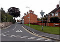
Summerfield Road, Wem
Looking east across Whitchurch Road.
Image: © Jaggery
Taken: 5 Oct 2014
0.08 miles
3
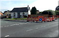
Roadworks near Foxleigh Lodge, Wem
On the corner of Foxleigh Grove and Whitchurch Road.
Image: © Jaggery
Taken: 5 Oct 2014
0.13 miles
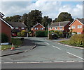
4
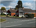
Foxleigh Drive bungalows, Wem
Set back from the east side of Whitchurch Road.
Image: © Jaggery
Taken: 5 Oct 2014
0.13 miles
7
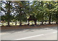
Tree-lined edge of Whitchurch Road Cemetery, Wem
This is the eastern side of the cemetery. Some sources refer to it as Love Lane Cemetery.
Image: © Jaggery
Taken: 5 Oct 2014
0.16 miles
8
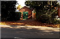
Haybarn electricity substation, Wem
Set back from the east side of Whitchurch Road. The identifier is 09-5129-23G HAYBARN SUBSTATION.
There is a Manweb Danger of Death - Keep Out yellow sign on a door.
Image: © Jaggery
Taken: 5 Oct 2014
0.16 miles
9
Grade II listed Creamore Grove in Wem
Set back from the west side of Whitchurch Road, Creamore Grove
dates from the first half of the 19th century. Grade II listed in 1983.
Image: © Jaggery
Taken: 5 Oct 2014
0.16 miles
10
The Paddock, Wem
Cul-de-sac on the west side of Whitchurch Road.
Image: © Jaggery
Taken: 5 Oct 2014
0.16 miles