IMAGES TAKEN NEAR TO
Orchard Way, SHREWSBURY, SY4 5DY
Introduction
This page details the photographs taken nearby to Orchard Way, SY4 5DY by members of the Geograph project.
The Geograph project started in 2005 with the aim of publishing, organising and preserving representative images for every square kilometre of Great Britain, Ireland and the Isle of Man.

There are currently over 7.5m images from over14,400 individuals and you can help contribute to the project by visiting https://www.geograph.org.uk
Image Map
Images are licensed for reuse under creativecommons.org/licenses/by-sa/2.0
Notes
- Clicking on the map will re-center to the selected point.
- The higher the marker number, the further away the image location is from the centre of the postcode.
Image Listing (114 Images Found)
Images are licensed for reuse under creativecommons.org/licenses/by-sa/2.0
Image
Details
Distance
1
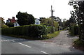
Orchard Way, Wem
Viewed from the Aston Road end. Orchard Way leads to houses in Harris Croft.
Image: © Jaggery
Taken: 5 Oct 2014
0.03 miles
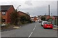
2
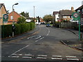
Aston Road, Wem
Viewed from the Orchard Way junction looking past the left turn for Prince William Court.
Image: © Jaggery
Taken: 5 Oct 2014
0.06 miles
3
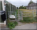
Kissing gate on a corner in Wem
On the corner of Orchard Way and Aston Road. A signpost shows Public Footpath to Leek Street.
A notice on the kissing gate shows ACCESS ONLY TO FOOTBRIDGE.
Image: © Jaggery
Taken: 5 Oct 2014
0.07 miles
4
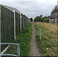
Public footpath to Leek Street, Wem
Viewed from this http://www.geograph.org.uk/photo/4195519 kissing gate.
The path to Leek Street is via a footbridge over railway lines SW of Wem station.
Image: © Jaggery
Taken: 5 Oct 2014
0.07 miles
6
Aston Road bus stop, Wem
The bus stop sign is on a lamppost, between Wem railway station
behind the camera and Orchard Way http://www.geograph.org.uk/photo/4195516 ahead.
Image: © Jaggery
Taken: 5 Oct 2014
0.11 miles
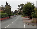
7
Southern end of Cordwell Park, Wem
Viewed across Aston Road. A sign shows HOME ZONE and a 20mph speed limit through Cordwell Park.
Image: © Jaggery
Taken: 5 Oct 2014
0.11 miles
8
Public footpath from Aston Road, Wem
The path on the right heads towards the River Roden.
Image: © Jaggery
Taken: 5 Oct 2014
0.11 miles
9
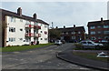
3-storey block of flats, Cordwell Park, Wem
On the east side of Cordwell Park, near the Aston Road junction.
Image: © Jaggery
Taken: 5 Oct 2014
0.12 miles
10
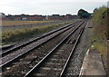
Lines SW from Wem railway station
Looking towards a green footbridge. This is the way to Shrewsbury, about 17km away.
The next station is Yorton, a request stop about 5km ahead.
Image: © Jaggery
Taken: 5 Oct 2014
0.13 miles