IMAGES TAKEN NEAR TO
Foxleigh Drive, SHREWSBURY, SY4 5BP
Introduction
This page details the photographs taken nearby to Foxleigh Drive, SY4 5BP by members of the Geograph project.
The Geograph project started in 2005 with the aim of publishing, organising and preserving representative images for every square kilometre of Great Britain, Ireland and the Isle of Man.

There are currently over 7.5m images from over14,400 individuals and you can help contribute to the project by visiting https://www.geograph.org.uk
Image Map
Images are licensed for reuse under creativecommons.org/licenses/by-sa/2.0
Notes
- Clicking on the map will re-center to the selected point.
- The higher the marker number, the further away the image location is from the centre of the postcode.
Image Listing (49 Images Found)
Images are licensed for reuse under creativecommons.org/licenses/by-sa/2.0
Image
Details
Distance
1
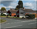
Foxleigh Drive bungalows, Wem
Set back from the east side of Whitchurch Road.
Image: © Jaggery
Taken: 5 Oct 2014
0.02 miles
2
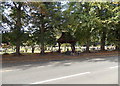
Tree-lined edge of Whitchurch Road Cemetery, Wem
This is the eastern side of the cemetery. Some sources refer to it as Love Lane Cemetery.
Image: © Jaggery
Taken: 5 Oct 2014
0.02 miles
3
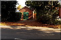
Haybarn electricity substation, Wem
Set back from the east side of Whitchurch Road. The identifier is 09-5129-23G HAYBARN SUBSTATION.
There is a Manweb Danger of Death - Keep Out yellow sign on a door.
Image: © Jaggery
Taken: 5 Oct 2014
0.03 miles
4
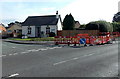
Roadworks near Foxleigh Lodge, Wem
On the corner of Foxleigh Grove and Whitchurch Road.
Image: © Jaggery
Taken: 5 Oct 2014
0.05 miles
5
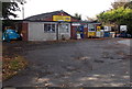
J.Jenkins Spares Ltd in Wem
Viewed across Love Lane, near the Whitchurch Road junction.
Image: © Jaggery
Taken: 5 Oct 2014
0.05 miles
6
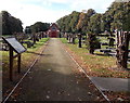
Yew-lined path to Whitchurch Road Cemetery chapel, Wem
The information board states that the chapel http://www.geograph.org.uk/photo/4218073 was built, and the yews were planted, in 1892.
The trees have been severely cut back in this October 2014 view.
Image: © Jaggery
Taken: 5 Oct 2014
0.05 miles
7
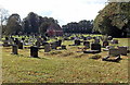
Whitchurch Road Cemetery, Wem
Viewed from Whitchurch Road looking towards the cemetery chapel. http://www.geograph.org.uk/photo/4218073
An information board near the cemetery entrance states that the cemetery dates from 1891, located on a 2.7 acre meadow land site. The chapel and lychgate were built soon after the cemetery opened, and 80 lime trees were planted. The yews http://www.geograph.org.uk/photo/4218098 flanking the central path were planted in 1892.
No new burials have taken place here since 1975, other than into existing family graves.
Image: © Jaggery
Taken: 5 Oct 2014
0.05 miles
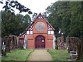
8
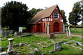
Whitchurch Road Cemetery chapel, Wem
An information board near the cemetery entrance states that the chapel, designed by London architect George H. Birch, was built in 1892, paid for by subscriptions from the people of Wem. The cemetery had opened in 1891.
Image: © Jaggery
Taken: 5 Oct 2014
0.05 miles
10
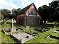
West side of Whitchurch Road Cemetery chapel, Wem
The chapel was built in 1892. See http://www.geograph.org.uk/photo/4218073 for another view.
Image: © Jaggery
Taken: 5 Oct 2014
0.06 miles