IMAGES TAKEN NEAR TO
Cordwell Park, SHREWSBURY, SY4 5BE
Introduction
This page details the photographs taken nearby to Cordwell Park, SY4 5BE by members of the Geograph project.
The Geograph project started in 2005 with the aim of publishing, organising and preserving representative images for every square kilometre of Great Britain, Ireland and the Isle of Man.

There are currently over 7.5m images from over14,400 individuals and you can help contribute to the project by visiting https://www.geograph.org.uk
Image Map
Images are licensed for reuse under creativecommons.org/licenses/by-sa/2.0
Notes
- Clicking on the map will re-center to the selected point.
- The higher the marker number, the further away the image location is from the centre of the postcode.
Image Listing (114 Images Found)
Images are licensed for reuse under creativecommons.org/licenses/by-sa/2.0
Image
Details
Distance
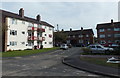
1
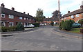
Western branch of Cordwell Park, Wem
Houses on the west side of the main north-south course of Cordwell Park.
Image: © Jaggery
Taken: 5 Oct 2014
0.02 miles
2

South through Cordwell Park, Wem
Houses between Soulton Road behind the camera and Aston Road ahead.
Image: © Jaggery
Taken: 5 Oct 2014
0.03 miles
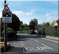
3
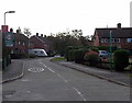
Northern end of Cordwell Park, Wem
Viewed across Soulton Road. A sign shows HOME ZONE and a 20mph speed limit through Cordwell Park.
Image: © Jaggery
Taken: 5 Oct 2014
0.06 miles
4
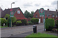
Cordwell Park, Wem
Local authorities seem to like branding their 20mph schemes on residential roads and here Cordwell Park, which leads off Soulton Road, is a 'home zone'.
Image: © Stephen McKay
Taken: 6 Jul 2021
0.06 miles
5
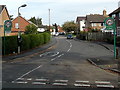
Southern end of Cordwell Park, Wem
Viewed across Aston Road. A sign shows HOME ZONE and a 20mph speed limit through Cordwell Park.
Image: © Jaggery
Taken: 5 Oct 2014
0.06 miles
6
3-storey block of flats, Cordwell Park, Wem
On the east side of Cordwell Park, near the Aston Road junction.
Image: © Jaggery
Taken: 5 Oct 2014
0.06 miles
7
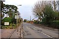
Soulton Road, Wem
A mainly residential road on the edge of the town. There is also an industrial estate accessed by this road.
Image: © P L Chadwick
Taken: 12 Mar 2011
0.07 miles
8
STOP when lights show, Wem
The sign is alongside Soulton Road 100 metres from Wem Level Crossing. http://www.geograph.org.uk/photo/4236121
Image: © Jaggery
Taken: 5 Oct 2014
0.07 miles
9
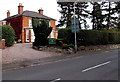
Aston Lodge, Wem
Guest house (bed and breakfast accommodation) viewed across the B5065 Soulton Road.
Image: © Jaggery
Taken: 5 Oct 2014
0.09 miles
10
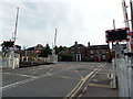
Wem level crossing
The road crosses the Welsh Marches Line at the NE end of Wem railway station.
Ahead are Soulton Road to the left and Aston Road to the right.
Image: © Jaggery
Taken: 5 Oct 2014
0.09 miles