IMAGES TAKEN NEAR TO
Drayton Road, SHREWSBURY, SY4 4NZ
Introduction
This page details the photographs taken nearby to Drayton Road, SY4 4NZ by members of the Geograph project.
The Geograph project started in 2005 with the aim of publishing, organising and preserving representative images for every square kilometre of Great Britain, Ireland and the Isle of Man.

There are currently over 7.5m images from over14,400 individuals and you can help contribute to the project by visiting https://www.geograph.org.uk
Image Map
Images are licensed for reuse under creativecommons.org/licenses/by-sa/2.0
Notes
- Clicking on the map will re-center to the selected point.
- The higher the marker number, the further away the image location is from the centre of the postcode.
Image Listing (61 Images Found)
Images are licensed for reuse under creativecommons.org/licenses/by-sa/2.0
Image
Details
Distance
2
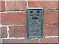
Ordnance Survey Flush Bracket S0219
This can be found on the roadside wall of a building at the junction of Church Street with the A53 in Shawbury.
For more detail see : http://www.bench-marks.org.uk/bm20371
Image: © Peter Wood
Taken: 6 Dec 2016
0.04 miles
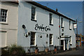
3
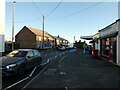
Scene on the main road through Shawbury, Shropshire
A very busy road and some local amenities.
Image: © Jeremy Bolwell
Taken: 2 Jan 2025
0.04 miles
4
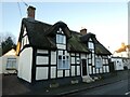
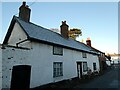
A thatched cottage on Church Street in Shawbury, Shropshire
Called the Thatched Cottage, I believe.
Image: © Jeremy Bolwell
Taken: 2 Jan 2025
0.06 miles
5
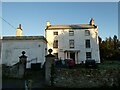
An old property off Church Street, Shawbury
The old vicarage, I believe.
Image: © Jeremy Bolwell
Taken: 2 Jan 2025
0.07 miles
6
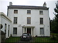
The Old Vicarage, Shawbury
Formerly the Vicarage, and built in the late 18th century, then modified in the 19th. It was Grade II listed https://britishlistedbuildings.co.uk/101366830-the-old-vicarage-shawbury#.YXBrBBrMLIU & https://historicengland.org.uk/listing/the-list/list-entry/1366830 in 1986.
Image: © Richard Law
Taken: 18 Oct 2021
0.07 miles
7
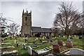
St. Mary The Virgin Church, Shawbury
Church of St. Mary the Virgin is a grade 1 listed Parish Church located in Shawbury, Shropshire. Late 12th Century with alterations in 1603 and 1875.
Historic England listing >> https://historicengland.org.uk/listing/the-list/list-entry/1055376
Shawbury Wiki >> https://en.wikipedia.org/wiki/Shawbury
OS intersection station >> http://trigpointing.uk/trig/11466
Image: © Brian Deegan
Taken: 25 Jan 2020
0.08 miles
8
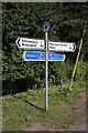
Old Direction Sign - Signpost by the B5063, Wem Road, Shawbury
Disc finial - 2 Worboys arms; Shropshire CC modern disc by the UC road, in parish of Shawbury (North Shropshire District), Shawbury.
Surveyed
Milestone Society National ID: SA_SJ5521
Image: © Milestone Society
Taken: Unknown
0.08 miles
9
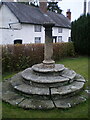
Sundial in the churchyard
The sundial dates from the late 18th century, and was Grade II listed https://britishlistedbuildings.co.uk/101055377-sundial-approximately-12-metres-to-north-west-of-tower-of-church-of-saint-mary-the-virgin-shawbury#.YXBlqRrMLIU & https://historicengland.org.uk/listing/the-list/list-entry/1055377 in 1986.
Image: © Richard Law
Taken: 18 Oct 2021
0.09 miles
10
An old property on Church Street in Shawbury, Shropshire
An interesting old property here, which looks vacant, and certainly historic.
Image: © Jeremy Bolwell
Taken: 2 Jan 2025
0.09 miles