IMAGES TAKEN NEAR TO
Shawbury, SHREWSBURY, SY4 4NR
Introduction
This page details the photographs taken nearby to SY4 4NR by members of the Geograph project.
The Geograph project started in 2005 with the aim of publishing, organising and preserving representative images for every square kilometre of Great Britain, Ireland and the Isle of Man.

There are currently over 7.5m images from over14,400 individuals and you can help contribute to the project by visiting https://www.geograph.org.uk
Image Map
Images are licensed for reuse under creativecommons.org/licenses/by-sa/2.0
Notes
- Clicking on the map will re-center to the selected point.
- The higher the marker number, the further away the image location is from the centre of the postcode.
Image Listing (5 Images Found)
Images are licensed for reuse under creativecommons.org/licenses/by-sa/2.0
Image
Details
Distance
1

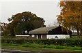
Outside Shawbury
The buildings appear to be of the kind you find over at RAF Shawbury but are not fenced in. It is mapped as a "Research Establishment".
Image: © Richard Webb
Taken: 17 Feb 2019
0.04 miles
2
Building with an unusual roof near Shawbury
Image: © Anthony Parkes
Taken: 6 Nov 2019
0.08 miles
3
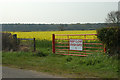
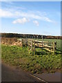
In case of accidents
Rapid access gate to/from RAF Shawbury
Image: © Row17
Taken: 22 Apr 2008
0.09 miles
4
Landing Lights
A row of Runway Landing Lights,near to Shawbury Airfield.
Image: © Paul Beaman
Taken: 29 Nov 2007
0.15 miles
5
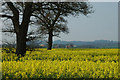
Oilseed Rape next to RAF Shawbury
RAF Shawbury control tower is in the middle distance.
Image: © Row17
Taken: 22 Apr 2008
0.23 miles