IMAGES TAKEN NEAR TO
Pool Farm Lane, SHREWSBURY, SY4 4NG
Introduction
This page details the photographs taken nearby to Pool Farm Lane, SY4 4NG by members of the Geograph project.
The Geograph project started in 2005 with the aim of publishing, organising and preserving representative images for every square kilometre of Great Britain, Ireland and the Isle of Man.

There are currently over 7.5m images from over14,400 individuals and you can help contribute to the project by visiting https://www.geograph.org.uk
Image Map
Images are licensed for reuse under creativecommons.org/licenses/by-sa/2.0
Notes
- Clicking on the map will re-center to the selected point.
- The higher the marker number, the further away the image location is from the centre of the postcode.
Image Listing (49 Images Found)
Images are licensed for reuse under creativecommons.org/licenses/by-sa/2.0
Image
Details
Distance
2
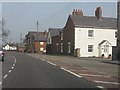
A49 in Hadnall
The scene a short distance north of the New Inn
Image: © Peter Whatley
Taken: 23 Mar 2012
0.05 miles
4
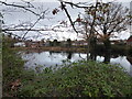
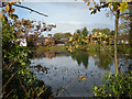
Pond in Hadnall
Popular with water birds.
Image: © Jeremy Bolwell
Taken: 30 Nov 2021
0.06 miles
5
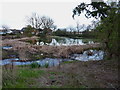
Hadnall pond - low water levels in late winter.
The pool looks a bit sorry for itself at this time of year, before the spring growth kicks in properly.
Image: © Richard Law
Taken: 5 Apr 2012
0.06 miles

7
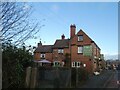
The New Inn at Hadnall, on the A49
Same view as in Image; the sign has been repainted
Image: © David Smith
Taken: 4 Dec 2021
0.08 miles
8
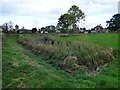
Moated Site at Hadnall
https://historicengland.org.uk/listing/the-list/list-entry/1019650?section=official-list-entry
Image: © Sandy Gerrard
Taken: 26 Oct 2022
0.08 miles
9
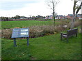
Hadnall moated site
The moated site is medieval, it is thought, and was first referred to in documents dating from 1327 when the village was part of large land holdings owned by various Earls of Shrewsbury and later Sheriffs of the county. In 1429 the large timber-framed house on this site was owned by a Thomas Banaster and that family held the property until the 18th century, when the house was derelict and was demolished or robbed out. The site was never re-used and was wooded and neglected until 2016 when it was restored to what we see today. It is surrounded by housing today.
Many moorhens here today.
Image: © Jeremy Bolwell
Taken: 30 Nov 2021
0.08 miles
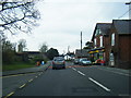
10
Station Road, Hadnall
View towards the junction with the A49.
Image: © Richard Webb
Taken: 17 Feb 2014
0.09 miles