IMAGES TAKEN NEAR TO
Wytheford Road, SHREWSBURY, SY4 4JH
Introduction
This page details the photographs taken nearby to Wytheford Road, SY4 4JH by members of the Geograph project.
The Geograph project started in 2005 with the aim of publishing, organising and preserving representative images for every square kilometre of Great Britain, Ireland and the Isle of Man.

There are currently over 7.5m images from over14,400 individuals and you can help contribute to the project by visiting https://www.geograph.org.uk
Image Map
Images are licensed for reuse under creativecommons.org/licenses/by-sa/2.0
Notes
- Clicking on the map will re-center to the selected point.
- The higher the marker number, the further away the image location is from the centre of the postcode.
Image Listing (5 Images Found)
Images are licensed for reuse under creativecommons.org/licenses/by-sa/2.0
Image
Details
Distance
3
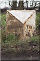
Old Milepost by the B5063, Wytheford Road, Shawbury
Cast iron milepost by the B5063, in parish of SHAWBURY (NORTH SHROPSHIRE District), Wytheford Road; Wytheford Heath; 425m South of Field House, by the road, on East side of road. Salop iron T-post, erected by the County Council in the 19th/20th century.
Inscription reads:-
: WELLINGTON / 8 / MILES : : WEM / 7 / MILES :
Grade II listed.
List Entry Number: 1366793 https://historicengland.org.uk/listing/the-list/list-entry/1366793
Milestone Society National ID: SA_WMWT07.
Image: © A Reade/J Higgins
Taken: 1 Sep 2007
0.12 miles