IMAGES TAKEN NEAR TO
Mytton Road, SHREWSBURY, SY4 4HT
Introduction
This page details the photographs taken nearby to Mytton Road, SY4 4HT by members of the Geograph project.
The Geograph project started in 2005 with the aim of publishing, organising and preserving representative images for every square kilometre of Great Britain, Ireland and the Isle of Man.

There are currently over 7.5m images from over14,400 individuals and you can help contribute to the project by visiting https://www.geograph.org.uk
Image Map
Images are licensed for reuse under creativecommons.org/licenses/by-sa/2.0
Notes
- Clicking on the map will re-center to the selected point.
- The higher the marker number, the further away the image location is from the centre of the postcode.
Image Listing (8 Images Found)
Images are licensed for reuse under creativecommons.org/licenses/by-sa/2.0
Image
Details
Distance
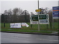
1
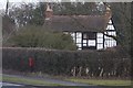
Old Toll House, Shawbury
Toll House set back from the A53, in the parish of Shawbury.
(Has this building been moved away from the road?)
To be surveyed
Milestone Society National ID: SA.SHA
Image: © Milestone Society
Taken: Unknown
0.13 miles
3
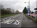
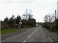
A53 Approaching Shawbury from Market Drayton
Image: © Peter Turner
Taken: 1 Jan 2012
0.18 miles
6
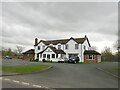
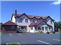
The Fox and Hounds
Describes itself as a "gastropub".
Image: © Richard Webb
Taken: 17 Mar 2022
0.20 miles