IMAGES TAKEN NEAR TO
Shawbury, SHREWSBURY, SY4 4HR
Introduction
This page details the photographs taken nearby to SY4 4HR by members of the Geograph project.
The Geograph project started in 2005 with the aim of publishing, organising and preserving representative images for every square kilometre of Great Britain, Ireland and the Isle of Man.

There are currently over 7.5m images from over14,400 individuals and you can help contribute to the project by visiting https://www.geograph.org.uk
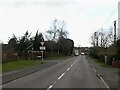
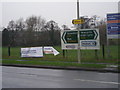
Image Map
Images are licensed for reuse under creativecommons.org/licenses/by-sa/2.0
Notes
- Clicking on the map will re-center to the selected point.
- The higher the marker number, the further away the image location is from the centre of the postcode.
Image Listing (12 Images Found)
Images are licensed for reuse under creativecommons.org/licenses/by-sa/2.0
Image
Details
Distance
1
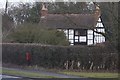
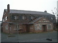
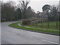
Old Toll House, Shawbury
Toll House set back from the A53, in the parish of Shawbury.
(Has this building been moved away from the road?)
To be surveyed
Milestone Society National ID: SA.SHA
Image: © Milestone Society
Taken: Unknown
0.07 miles
4
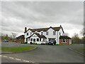
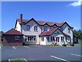
The Fox and Hounds
Describes itself as a "gastropub".
Image: © Richard Webb
Taken: 17 Mar 2022
0.14 miles
10
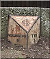
Old Milepost by the A53, Shawbury Bridge, Shawbury
Cast iron post by the A53, in parish of SHAWBURY (NORTH SHROPSHIRE District), Shawbury Bridge; West side of bridge in village, by the road, on North side of road. Salop iron T-post, erected by the County Council in the 19th/20th century.
Inscription reads:-
: WELLINGTON / 9 / MILES : : WEM / 6 / MI(LES) :
Grade II listed.
List Entry Number: 1055413 https://historicengland.org.uk/listing/the-list/list-entry/1055413
Milestone Society National ID: SA_WMWT06.
Image: © A Read /M Faherty
Taken: 26 Aug 2008
0.20 miles