IMAGES TAKEN NEAR TO
McKinley Way, SHREWSBURY, SY4 4HN
Introduction
This page details the photographs taken nearby to McKinley Way, SY4 4HN by members of the Geograph project.
The Geograph project started in 2005 with the aim of publishing, organising and preserving representative images for every square kilometre of Great Britain, Ireland and the Isle of Man.

There are currently over 7.5m images from over14,400 individuals and you can help contribute to the project by visiting https://www.geograph.org.uk
Image Map
Images are licensed for reuse under creativecommons.org/licenses/by-sa/2.0
Notes
- Clicking on the map will re-center to the selected point.
- The higher the marker number, the further away the image location is from the centre of the postcode.
Image Listing (5 Images Found)
Images are licensed for reuse under creativecommons.org/licenses/by-sa/2.0
Image
Details
Distance
3
Old hangars near RAF Shawbury
I do not know what purpose these hangars are put to now. It looks to be non-military.
Aren't hangars interesting buildings; quite unlike most other buildings in shape and, indeed, purpose.
Image: © Jeremy Bolwell
Taken: 2 Jan 2025
0.21 miles
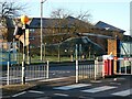
4
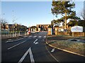
The main gate of RAF Shawbury
I think this base trains helicopter pilots.
RAF information on this base https://www.raf.mod.uk/our-organisation/stations/raf-shawbury/
Image: © Jeremy Bolwell
Taken: 2 Jan 2025
0.24 miles
5
Gate guardian at RAF Shawbury
A Wessex helicopter. I flew in one of these when I was an Air Cadet as a youth. Great fun.
Wikipedia https://en.wikipedia.org/wiki/Westland_Wessex on Wessex helicopters.
Image: © Jeremy Bolwell
Taken: 2 Jan 2025
0.25 miles