IMAGES TAKEN NEAR TO
Moreton Mill, Shawbury, SHREWSBURY, SY4 4ER
Introduction
This page details the photographs taken nearby to SY4 4ER by members of the Geograph project.
The Geograph project started in 2005 with the aim of publishing, organising and preserving representative images for every square kilometre of Great Britain, Ireland and the Isle of Man.

There are currently over 7.5m images from over14,400 individuals and you can help contribute to the project by visiting https://www.geograph.org.uk
Image Map
Images are licensed for reuse under creativecommons.org/licenses/by-sa/2.0
Notes
- Clicking on the map will re-center to the selected point.
- The higher the marker number, the further away the image location is from the centre of the postcode.
Image Listing (6 Images Found)
Images are licensed for reuse under creativecommons.org/licenses/by-sa/2.0
Image
Details
Distance
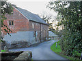
3
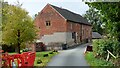
Morton Mill
https://historicengland.org.uk/listing/the-list/list-entry/1387402?section=official-list-entry
Image: © Sandy Gerrard
Taken: 21 Oct 2022
0.18 miles
4
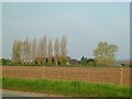
Old Farm guest house
Old farm converted to guest house Nr Edgebolton
Image: © Andy and Hilary
Taken: 22 Apr 2005
0.21 miles