IMAGES TAKEN NEAR TO
Acton Reynald, SHREWSBURY, SY4 4DU
Introduction
This page details the photographs taken nearby to SY4 4DU by members of the Geograph project.
The Geograph project started in 2005 with the aim of publishing, organising and preserving representative images for every square kilometre of Great Britain, Ireland and the Isle of Man.

There are currently over 7.5m images from over14,400 individuals and you can help contribute to the project by visiting https://www.geograph.org.uk
Image Map
Images are licensed for reuse under creativecommons.org/licenses/by-sa/2.0
Notes
- Clicking on the map will re-center to the selected point.
- The higher the marker number, the further away the image location is from the centre of the postcode.
Image Listing (9 Images Found)
Images are licensed for reuse under creativecommons.org/licenses/by-sa/2.0
Image
Details
Distance
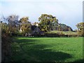
1
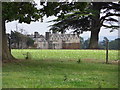
Acton Reynald
School building at Acton Reynald as viewed from the A49 opposite the Grinshill junction.
Image: © J Scott
Taken: 15 Jul 2011
0.03 miles
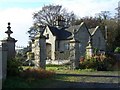
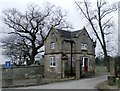
2
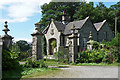
Lodge, Acton Reynald
Former east lodge to Acton Reynald, dated 1869. Like much else here, built of Grinshill stone which is quarried only a stone's throw away.
Image: © Stephen Richards
Taken: Unknown
0.18 miles
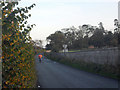
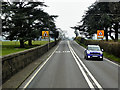
9
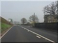
A49 at the gatehouse for Acton Reynald
The road sign is highly misleading. The junction for which it applies is over 100 yards ahead.
Image: © Peter Whatley
Taken: 23 Mar 2012
0.25 miles